 | ||
|
[+] Mailing label | ||
Lookups: 145673
| ||
| Email: info@d4c.cc QSL: BUREAU AND DIRECT VIA IZ4DPV - ALSO LOTW | ||
We finally have found a good on-line engine for log search.
Just click on the " Log Search" menu on the home page of our site (www.d4c.cc), put your call and click "search".
If you are in one of our logs,a small table will appearand will show you where you worked us and in which mode.
If you are in one of our logs,a small table will appearand will show you where you worked us and in which mode.
If youwish to be more sure about your presence inour logs just fill in the on-line request with full data qso and we will come back toyou.
At this point you will know exactlyfor which qso(s) you can send your direct qsl cards.
At this point you will know exactlyfor which qso(s) you can send your direct qsl cards.
If you prefer you can avoid to send your qsl cards, simply request it byfilling the same form and we will give you instructions how to send us a donation to cover qsl expenses (paypaluser only).
Stillvalid the LoTW and EQSL on-line upload logs.
Best 73's
*********************************************************************************
We are now on FB.
please join us on the link https://www.facebook.com/D4C.STATION
Many updates!
*********************************************************************************
If you wish to receive direct QSL CARDS please send us a contribution to cover mail expenses as per following rates:
UPDATED MAIL RATES 2011 May
ITALY 0,60 Euro
EUROPE AND ISRAEL 0,75 Euro (1 USD)
ASIA AND AMERICA 1,60 Euro (2 USD)
AUSTRALIA AND OCEANIA 2,00 Euro (3 USD)
TNX
******************************************************************************* *****
> Written by IK2NCJ > venerdì, 15 agosto 2008 > > IMPORTANT NOTICE:
> > If you ever received return qsl cards sent to D4C via bureau with the print "ARI - NOT MEMBER" please be so kind to send a scan > of it to "info at d 4 c . c c"
> > Direct cards remain processed by usual manager IZ4DPV.
vy 73 Uli DG7LAE
******************************************************************************* *****
20121124 0731UTC 14056.76kHz D4C
Date : 24/Nov/2012 0731UTC
Freq : 14056.76kHz CW
Rig : KENWOOD TS-870S
ANT : LOOP
PC recording
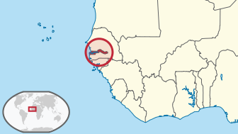
Cape Verde  i/ˌkeɪp ˈvɜrd/ (Portuguese: Cabo Verde, pronounced: [ˈkabu ˈveɾdɨ]), officially the Republic of Cape Verde, is an island country, spanning an archipelago of 10 islands located in the central Atlantic Ocean, 570 kilometres (350 miles) off the coast of Western Africa. The islands, covering a combined area of slightly over 4,000 square kilometres (1,500 sq mi), are of volcanic origin and while three of them (Sal, Boa Vista and Maio) are fairly flat, sandy and dry, the remaining ones are generally rockier and have more vegetation. However, because of infrequent rainfall, the islands are not particularly green.
The name of the country stems from the nearby Cap Vert, on the Senegalese coast,[5] which in its turn was originally named "Cabo Verde" when it was sighted by Portuguese explorers in 1444, a few years before the islands were discovered (verde is Portuguese for "green").
The previously uninhabited islands were discovered and colonized by the Portuguese in the 15th Century, and became important in the Atlantic slave trade for their location. The islands' prosperity often attracted privateers and pirates, including Sir Francis Drake, a corsair (privateer) under the authority of the British crown, who twice sacked the (then) capital Ribeira Grande, in the 1580s. The islands were also visited by Charles Darwin's expedition in 1832. The decline in the slave trade in the 19th century resulted in an economic crisis for the islands. With few natural resources, and without strong sustainable investment from the Portuguese, the citizens grew increasingly discontent with the colonial masters, who nevertheless refused to provide the local authorities with more autonomy. A budding independence movement culminated in 1975, when a movement originally led by Amílcar Cabral (who was assassinated on 20 January 1973) then passed onto his half-brother Luís Cabral, achieved independence for the archipelago.
.svg/600px-Cape_Verde_(orthographic_projection).svg.png) The country has an estimated population (most of creole ethnicity) of about 500,000, with its capital city Praiaaccounting for a quarter of its citizens. Nearly 38% of the population lives in rural areas according to the 2010 Cape Verdean census; about 10.6% lives below the poverty threshold, according to the world bank data |2011|, and the literacy rate is around 85%. Politically, the country is a very stable democracy, with notable economic growth and improvements of living conditions despite its lack of natural resources, and has garnered international recognition by other countries and international organizations, which often provide development aid. Since 2007, Cape Verde has been classified as a developing nation.
The country has an estimated population (most of creole ethnicity) of about 500,000, with its capital city Praiaaccounting for a quarter of its citizens. Nearly 38% of the population lives in rural areas according to the 2010 Cape Verdean census; about 10.6% lives below the poverty threshold, according to the world bank data |2011|, and the literacy rate is around 85%. Politically, the country is a very stable democracy, with notable economic growth and improvements of living conditions despite its lack of natural resources, and has garnered international recognition by other countries and international organizations, which often provide development aid. Since 2007, Cape Verde has been classified as a developing nation.
Tough economic times during the last decades of its colonization and the first years of Cape Verde's independence led many to migrate to Europe, the Americas and other African countries. This migration was so significant that the number of Cape Verdeans and their descendants living abroad currently exceeds the population of Cape Verde itself. Historically, the influx of remittances from these immigrant communities to their families has provided a substantial contribution to help strengthen the country's economy. Currently, the Cape Verdean economy is mostly service-oriented with a growing focus on tourism and foreign investment, which benefits from the islands' warm climate throughout the year, diverse landscape, welcoming people[citation needed] and cultural wealth, especially in music.


")
