 | ||
C5A
CQ WW Contests . QSL via OM2FY The Gambia [+] Mailing label | ||
Lookups: 50418
| ||
| Email: Use mouse to view.. QSL: VIA OM2FY
NEW !!! curent news on facebook profile:radiosyd c5a contest group
QSL OM2FY
CQ WW DX CW Contest 2010: 27.-28.11. 2010 - QTH: Banjul
CQ WW DX SSB Contest 2011: 29.-30.10. 2011 - QTH: Banjul
CQ WW DX CW Contest 2011: 26.-27.11. 2011 - QTH: Banjul
CQ WW DX SSB Contest 2012: 27.-28.10. 2012 - QTH: Banjul
CQ WW DX CW Contest 2012: 24.-25.11. 2012 - QTH: Banjul
| ||
20121124 0742UTC 14059.21kHz C5A
Date : 24/Nov/2012 0742UTC
Freq : 14059.21kHz CW
Rig : KENWOOD TS-870S
ANT : LOOP
PC recording

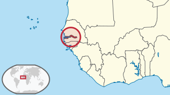
The country is situated around the Gambia River, the nation's namesake, which flows through the country's centre and empties into the Atlantic Ocean. Its area is 11,295 km² with an estimated population of 1.7 million.
On 18 February 1965, The Gambia gained independence from the United Kingdom and joined the Commonwealth of Nations. Banjul is The Gambia's capital, but the largest cities are Serekunda and Brikama.
The Gambia shares historical roots with many other West African nations in the slave trade, which was the key factor in the placing and keeping of a colony on the Gambia River, first by the Portuguese and later by the British. Since gaining independence in 1965, The Gambia has enjoyed relative political stability, with the exception of a brief period of military rulein 1994.[3][4]
Thanks to the fertile land of the country, the economy is dominated by farming, fishing, and tourism. About a third of the population lives below the international poverty line of US$1.25 a day.[5]
Geography

Main article: Geography of the Gambia
The Gambia is a very small and narrow country whose borders mirror the meandering Gambia River. It lies between latitudes 13° and 14°N, and longitudes 13° and 17°W.
The country is less than 48.2 km (30.0 mi) wide at its widest point, with a total area of 11,295 km². Approximately 1,300 km² of The Gambia's area is covered by water. It is the smallest country on the continent of Africa. In comparative terms The Gambia has a total area which is slightly less than that of the island of Jamaica. The western side of the country borders the North Atlantic Ocean with 50 miles of coastline.[10]
The climate of The Gambia is tropical. There is a hot and rainy season, normally from June until November, but from then until May there are cooler temperatures with less precipitation.[10] The climate in The Gambia is about the same as that found in neighbouring Senegal, southern Mali, and the northern part of Benin.[11]
Its present boundaries were defined in 1889 after an agreement between the United Kingdom and France. During the negotiations between the French and the British in Paris, the French initially gave the British approximately 200 miles (320 km) of the Gambia River to control. Starting with the placement of boundary markers in 1891, it took nearly fifteen years after the Paris meetings to determine the final borders of The Gambia. The resulting series of straight lines and arcs gave the British control of areas that are approximately 10 miles (16 km) north and south of the Gambia River.[12]
No comments:
Post a Comment