Friday, November 30, 2012

AH0J(Mariana Islands) on 40m LSB!!!

AH0J(Mariana Islands) on 40m LSB!!!

QSL image for AH0J
AH0J Mariana Islands flag Mariana Islands KATSUMI YOSHINUMA
PO BOX 502571
SAN JOSE, MP 96950
USA

[+] Mailing label
Lookups:   85914
Email: Use mouse to view.. QSL: JA1NVF, PLS DO NOT SEND TO TINIAN DIRECT


20121129 2015UTC 7145kHz AH0J
Date : 29/Nov/2012 2015UTC 
Freq : 7145kHz LSB 
Rig : KENWOOD TS-870S
ANT : LOOP(for 20m not enough gain) 
PC recording


The Mariana Islands (also the Marianas; up to the early 20th century sometimes called Ladrones Islands, from Spanish Islas de los Ladrones meaning "Islands of Thieves") are an arc-shaped archipelagomade up by the summits of fifteen volcanic mountains in the north-western Pacific Ocean between the12th and 21st parallels north and along the 145th meridian east. They are south of Japan and north of New Guinea, and form the eastern limit of the Philippine Sea. The islands were named after Spanish QueenMariana of Austria in the 17th century, when Spain started the colonization of the archipelago. They form the northern part of the western Pacific subregion of Micronesia, and are composed of two U.S. jurisdictions: the Commonwealth of the Northern Mariana Islands and, at the southern end of the chain of islands, the territory of Guam.

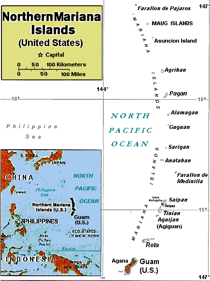
The islands are part of a geologic structure known as the Izu-Bonin-Mariana Arc system, and range in age from 5 million years old in the north to 30 million years old in the south (Guam). The island chain arises as a result of the western edge of the Pacific Plate moving westward and plunging downward below theMariana plate, a region which is the most volcanically active convergent plate boundary on Earth. Thissubduction region, just east of the island chain, forms the noted Mariana Trench, the deepest part of the Earth's oceans and lowest part of Earth's crust. In this region, according to geologic theory, water trapped in the extensive faulting of the Pacific Plate as serpentinite, is heated by the higher temperatures of depth during its subduction, and the pressure from the expanding steam results in the hydrothermal activity in the area, and the volcanic activity which formed the Mariana Islands.[1]


7Z1RR(Saudi Arabia) on 40m LSB!!!

7Z1RR(Saudi Arabia) on 40m LSB!!!

QSL image for 7Z1RR
7Z1RR Saudi Arabia flag Saudi Arabia BANDER ALSUFYANI ALTHAGAFY
jeddah
JEDDAH
Saudi Arabia

[+] Mailing label
Lookups:   30637 Ham Member
Email: Use mouse to view.. 


20121129 1900UTC 7093kHz 7Z1RR
Date : 29/Nov/2012 1900UTC 
Freq : 7093kHz LSB 
Rig : KENWOOD TS-870S
ANT : LOOP(for 20m not enough gain) 
PC recording


Saudi Arabia (Listeni/ˌsdi əˈrbi.ə/ or Listeni/ˌsɔːd əˈrbi.ə/Arabicالسعودية‎ as-Su‘ūdiyyah or as-Sa‘ūdiyyah), officially known as theKingdom of Saudi Arabia (Arabicالمملكة العربية السعودية‎ al-Mamlakah al-‘Arabiyyah as-Su‘ūdiyyah About this sound Arabic pronunciation), is the largest Arab state in Western Asia by land area, constituting the bulk of the Arabian Peninsula, and the second-largest in the Arab world (after Algeria). It is bordered by Jordan and Iraq on the north and northeast, Kuwait,QatarBahrain and the United Arab Emirates on the east, Oman on the southeast, and Yemen on the south. The Red Sea lies to its west, and the Persian Gulf lies to the east. Saudi Arabia has an area of approximately 2,250,000 km2 (870,000 sq mi), and it has an estimated population of 27 million, of which 9 million are registered foreign expatriates and an estimated 2 million are illegal immigrants. Saudi nationals comprise an estimated 16 million people.[7]
The Kingdom of Saudi Arabia was founded by Abdul-Aziz bin Saud (known for most of his career as Ibn Saud) in 1932, although the conquests which eventually led to the creation of the Kingdom began in 1902 when he captured Riyadh, the ancestral home of his family, the House of Saud, referred to in Arabic as Al Saud. The Saudi Arabian government, which has been an absolute monarchy since its inception, refers to its system of government as Islamic. The kingdom is sometimes called "The Land of the Two Holy Mosques" in reference to Al-Masjid al-Haram (in Mecca), and Al-Masjid al-Nabawi (in Medina), the two holiest places in Islam.
Saudi Arabia has the world's second largest oil reserves which are concentrated largely in the Eastern Province[8][9] and oil accounts for more than 95% of exports and 70% of government revenue. This facilitates the creation of a welfare state[10]although the share of the non-oil economy is growing recently. It has also the world's sixth largest natural gas reserves.

Thursday, November 29, 2012

7P8D(Lesotho) on 40m CW!!!

7P8D(Lesotho) on 40m CW!!!


7P8D Lesotho flag Lesotho 2012 Lesotho DX pedition 7P8D DX Pedition
P O Box 29169
Sunridge Park 6008
South Africa

[+] Mailing label
Lookups:   40059
Email: Use mouse to view.. QSL: DIRECT AS PER WEBSITE


20m用のアンテナなのでGain不足です。
非常に薄い信号ですが、なんとか聞き取れるレベルです。

20121128 2008UTC 7026kHz 7P8D
Date : 28/Nov/2012 2008UTC 
Freq : 7026kHz CW 
Rig : ICOM IC-7200
ANT : LOOP(for 20m not enough gain) 
PC recording


Lesotho (Listeni/lɨˈst/ li-soo-too), officially the Kingdom of Lesotho, is a landlocked country and enclave, completely surrounded by its only neighbouring country, the Republic of South Africa. It is just over 30,000 km2 (11,583 sq mi) in size with a population of approximately 2,067,000.[1] Its capital and largest city is Maseru. Lesotho is a member of the Commonwealth of Nations. The nameLesotho translates roughly into the land of the people who speak Sesotho.[4] About 40% of the population live below theinternational poverty line of US $1.25 a day.[5]


Geography


Satellite image of Lesotho

Landscape of Lesotho
Lesotho covers 30,355 km2 (11,720 sq mi). It is the only independent state in the world that lies entirely above 1,000 metres (3,281 ft) in elevation. Its lowest point of 1,400 metres (4,593 ft) is thus the highest in the world. Over 80% of the country lies above 1,800 metres (5,906 ft). Lesotho is also the southernmost landlocked country in the world and is entirely surrounded by the country of South Africa. It lies between latitudes 28° and 31°S, and longitudes 27° and 30°E.

[edit]Climate

Because of its altitude, Lesotho remains cooler throughout the year than other regions at the same latitude. Most of the rain falls as summer thunderstormsMaseru and surrounding lowlands often reach 30 °C (86 °F) in summer. Winters can be cold with the lowlands getting down to −7 °C (19 °F) and the highlands to −18 °C (−0 °F) at times. Snow is common in the highlands between May and September; the higher peaks can experience snowfalls year-round.


Wednesday, November 28, 2012

Again V63EPO(Micronesia) on 20m RTTY!!!

Again V63EPO(Micronesia) on 20m RTTY!!!


V63EPO Micronesia flag Micronesia Masahiko Ishizuka
JA7EPO
Pohnpei
Micronesia

[+] Mailing label
Lookups:   1968
QSL: VIA JA7EPO DIRECT ONLY


20121128 0702UTC 14085kHz V63EPO
Date : 28/Nov/2012 0702UTC 
Freq : 14085kHz RTTY 
Rig : ICOM IC-7200
ANT : LOOP 
PC recording


NP3X(Puerto Rico) on 20m on CQ WW CW Contest!!!

NP3X(Puerto Rico) on 20m on CQ WW CW Contest!!!

QSL image for NP3X
NP3X Puerto Rico flag Puerto Rico COAMO CONTEST CLUB
PO BOX 1043
COAMO, PR 00769-1043
USA

[+] Mailing label
Lookups:   8003
Email: Use mouse to view.. QSL: VIA DIRECT (NP3O) OR VIA LOTW


20121124 2147UTC 14016.5kHz NP3X
Date : 24/Nov/2012 2147UTC 
Freq : 14016.5kHz CW 
Rig : KENWOOD TS-870S 
ANT : LOOP 
PC recording


Puerto Rico (/ˌpɔrtə ˈrk/ or /ˌpwɛərtə ˈrk/[note 1]Spanish pronunciation: [pʷeɾto ˈriko] officially the Commonwealth of Puerto Rico (Spanish: Estado Libre Asociado de Puerto Rico—literally, "Associated Free State of Puerto Rico"), is anunincorporated territory of the United States, located in the northeastern Caribbean, east of the Dominican Republic and west of both the United States Virgin Islands and the British Virgin Islands.
Puerto Rico (Spanish for "rich port") comprises an archipelago that includes the main island of Puerto Rico and a number of smaller islands, the largest of which are ViequesCulebra, and Mona. The main island of Puerto Rico is the smallest by land area of the Greater Antilles. However, it ranks third in population among that group of four islands, which also includeCubaHispaniola (Dominican Republic and Haiti), and Jamaica. Due to its location, Puerto Rico enjoys a tropical climate and also experiences the Atlantic hurricane season.
Originally populated for centuries by indigenous aboriginal peoples known as Taínos, the island was claimed by Christopher Columbus for Spain during his second voyage to the Americas on November 19, 1493. Under Spanish rule, the island was colonized and the indigenous population was forced into slavery and nearly wiped out due to, among other things, European infectious diseases. The remaining population was emancipated by King Charles I in 1520. Spain possessed Puerto Rico for over 400 years, despite attempts at capture of the island by the French, Dutch, and British. The Spanish Crown, in an attempt to keep Puerto Rico from gaining its independence, revived the Royal Decree of Graces of 1815. The decree was printed in three languages—SpanishEnglish and French—and it fostered the immigration of hundreds of non-Spanish European families.[14]
The relationship between Puerto Rico and the United States dates back to the Spanish-American War, in which Spain, under the terms of the Treaty of Paris of 1898, ceded the island to the United States. In 1917, Puerto Ricans became U.S. citizens and, today, "the United States Congress legislates many fundamental aspects of Puerto Rican life".[15] However, the islanders may not vote in U.S. presidential elections.[16][17] Since 1947, Puerto Ricans have been able to elect their own governor. Its official languages are Spanish and English, with Spanish being the primary language. The island's currentpolitical status, including the possibility of statehood or independence, is widely debated in Puerto Rico. In a non-bindingreferendum held on November 6, 2012, 53% of respondents voted against the current status, while in a second question 65% favored statehood as the preferred alternative.[18]