Thursday, September 27, 2012

RI1FJ(Franz Josef Land) on 20m CW !!

RI1FJ(Franz Josef Land)  on 20m CW !!


Franz Josef LandFranz Joseph Land, or Francis Joseph's Land (RussianЗемля Франца-ИосифаZemlya Frantsa-Iosifa) is an archipelago located in the far north of Russia. It is found in the Arctic Ocean north of Novaya Zemlya and east of Svalbard, and is administered by Arkhangelsk Oblast. Franz Josef Land consists of 191 ice-covered islands with a total area of 16,134 km2 (6,229 sq mi). It has no native inhabitants, but several settlements have been built by Russian settlers. They rely solely on walrus and seal meat.
At latitudes between 80.0° and 81.9° north, it is the most northerly group of islands associated with Eurasia. The extreme northernmost point is Cape Fligely on Rudolf Island. The archipelago is only 900 to 1,110 km (560 to 690 miles) from the North Pole, and the northernmost islands are closer to the Pole than any other land except for Canada's Ellesmere Island and Greenland.
The archipelago was possibly first discovered by the Norwegian sealers Nils Fredrik Rønnbeck and Aidijärvi aboard the schooner Spidsbergen in 1865 who, according to scarce reports, sailed eastward from Svalbard until they reached a new land, denoted Nordøst-Spitsbergen (Spitsbergen was the contemporary name of Svalbard). It is not known if they went ashore, and the new islands were soon forgotten.
The officially recognized discovery took place in 1873 by the Austro-Hungarian North Pole Expedition led by polar explorers Julius von Payer and Karl Weyprecht. They named the archipelago in honour of the Austro-Hungarian emperor Franz Joseph I. Since the expedition was privately sponsored and not official, these islands have not been part of Austria.
In 1926 the islands were taken over by the Soviet Union, and a few people were settled for research and military purposes. Access by ships is possible only for a few summer weeks and a special permit is required to visit the islands.


フランツ・ヨーゼフ諸島(ふらんつよーぜふしょとう、Zemlya Frantsa-Iosifaゼムリャ・フランツァ=ヨシファロシア語ではЗемля Франца-Иосифаズィムリャー・フラーンツァ・ヨースィファ)は、北極海の一部であるバレンツ海に位置するロシア連邦領の約190のから構成されている島嶼群である。


スピッツベルゲン島の東に位置しアルハンゲリスク州に属している。アレクサンドラ島ゲオルグ島ブリュサ島グケラ島ノルトブルク島ビリチェク島グレエムベル島ヘイス島などの島で構成されている。北緯80.0度から81.9度の範囲にあり、ユーラシア大陸で最も北にあるグループである。最北端はルドルフ島のフリゲリ岬(mys Fligeli)で、北緯81度52分。この群島は北極点からわずかに900から1100キロメートルにあり、カナダエルズミーア島グリーンランドに次いで近い。総面積は1万6100km²で最高点はヴィナーネイシュタット島(Zemlya Viner-Neyshtadt)にある標高620mの雪原。大きな島は東部にあるビリチェク島(2000km²)、西部にあるゲオルグ島(2741km²)など。大部分は無人である。かつて巨大な玄武岩台地の島が形成されたが、侵食されて多数の島になったと考えられる。島々の標高も350-500m程度でそろっている。表面は、総面積の85%までが氷河[1]や雪原で、そのほかも裸地が多い。1865年ロシアの研究者のシリングが探検し、1873年カール・ヴァイプレヒトによるオーストリア・ハンガリー帝国調査隊の探検があり、皇帝フランツ・ヨーゼフ1世を記念して諸島名とした(名称は、ロシア語で「フランツ・ヨーゼフの土地」という意味である)。
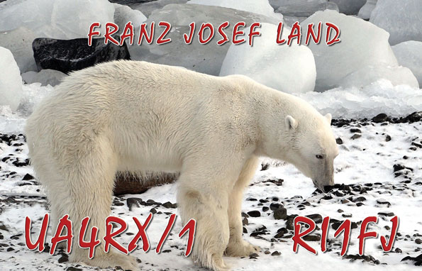
1926年にこの群島はソビエト連邦に吸収され、研究と軍事目的で少数の人間が移住した。船でのアクセスは夏の数週間に限られ、また特別の許可が必要である

RI1FJ Eugeny Chepur
Today.s 20m spot
JJ5IZX-@  14008.0 RI1FJ   Tnx fer QSO 73's Loud in JA      1025 26 Sep Franz Josef Land
UN7LZ     14008.0 RI1FJ   TKS QSO, another stn this freq   1020 26 Sep Franz Josef Land
VK3SX     14008.0 RI1FJ   Tnx Eugeny nice big sigs tu 73   1014 26 Sep Franz Josef Land
VK2DX     14008.0 RI1FJ   L O U D !!                       1007 26 Sep Franz Josef Land


一度はQSOできたはずですが、QRMの為不確かだった。
今回はお聞きのように強力に入感していたのでなんら問題はない

他の局もReportしていますが、非常に強力に入感していました。
そういえば先日からHibandでの活動が良く聞かれていたようですが・・・

※ 今回は非常に短い録音です、この後QSYした模様です。

20120926 1023UTC 14008kHz RI1FJ


Date : 26/Sep/2012 1023UTC 
Freq : 14008kHz CW 
Rig : ICOM IC-7200 
ANT : LOOP 
PC recording 


Tuesday, September 25, 2012

PY4BZM(Brazil) JOSE on 20m CW !!

PY4BZM(Brazil) JOSE on 20m CW !!


 Hello OM Jose san

Tnx fer 1st QSO and  now recording your QSO.

Please listen it and many thanks your corporation

Cu agn DXer Jose san 73's

Best regards


DX Cluster spot

JJ5IZX-@  14014.1 PY4BZM  Tnx fer QSO JOSE 73's  and 10w QSO  0819 25 Sep Brazil

20120925 0806UTC 14014kHz PY4BZM


Date : 25/Sep/2012 0806UTC 
Freq : 14014kHz CW 
Rig : ICOM IC-7200 
ANT : LOOP 
PC recording 


Again!! KP2/K5WE(St.Croix, US Virgin Islands) on 20m CW!!

Again!! KP2/K5WE(St.Croix, US Virgin Islands) on 20m CW!!


The U.S. Virgin Islands are in the Caribbean Sea and the Atlantic Ocean, about 40 miles (64 km) east of Puerto Rico and immediately west of theBritish Virgin Islands. The territory consists of four main islands: Saint ThomasSaint JohnSaint Croix, and Water Island, as well as several dozen smaller islands. The main islands have nicknames often used by locals: "Twin City" (St. Croix), "Rock City" (St. Thomas) and "Love City" (St. John).[9] The combined land area of the islands is roughly twice the size of Washington, D.C.
The U.S. Virgin Islands are known for their white sand beaches, includingMagens Bay and Trunk Bay, and strategic harbors, including Charlotte Amalieand Christiansted. Most of the islands, including Saint Thomas, are volcanic in origin and hilly. The highest point is Crown Mountain, Saint Thomas (1,555 ft/474 m).
Saint Croix, the largest of the U.S. Virgin Islands, lies to the south and has a flatter terrain. The National Park Service owns more than half of Saint John, nearly all of Hassel Island, and many acres of coral reef. (See also Virgin Islands National ParkVirgin Islands Coral Reef National MonumentBuck Island Reef National MonumentChristiansted National Historic Site, and Salt River Bay National Historical Park and Ecological Preserve.)
The U.S. Virgin Islands lie on the boundary of the North American plate and the Caribbean Plate. Natural hazards include earthquakes and tropical cyclones (including hurricanes).


K5WE said


I will be operating from KP2, St. Croix, US Virgin Islands, as KP2/K5WE beginning 17Sept12 until 26Sep12. QSL via home call.
-----------------------------------------------------------------------------------------------------------
Operated from Bonaire as PJ4/K5WE 3Jul2011 to 11Jul2011. QSL via home call.


Near spot 25


K4DY        7004.0 KP2/K5WE     CQ                         2333 24 Sep   US Virgin Island
KC0CF      10117.5 KP2/K5WE                                2319 24 Sep   US Virgin Island
W3LPL      10117.5 KP2/K5WE                                2307 24 Sep   US Virgin Island
W3LPL      18072.1 KP2/K5WE                                2251 24 Sep   US Virgin Island
W3LPL      18071.1 KP2/K5WE                                2250 24 Sep   US Virgin Island
EA5CI      14032.0 KP2/K5WE     cq cq cq                   2249 24 Sep   US Virgin Island
VK6DU      14032.0 KP2/K5WE     big sigs VK6 qrz simplex   2222 24 Sep   US Virgin Island
VK8AV-@    14032.0 KP2/K5WE     big sig in VK              2217 24 Sep   US Virgin Island
LY3G-@     10127.9 KP2/K5WE     tu qso my 5w               2055 24 Sep   US Virgin Island
W3LPL      10128.0 KP2/K5WE                                2049 24 Sep   US Virgin Island
OZ4CG-@    21032.9 KP2/K5WE     QSX 21034.2                2020 24 Sep   US Virgin Island
LY3G-@     21032.9 KP2/K5WE     TU QSO my 5W               2006 24 Sep   US Virgin Island
UR4EZ      21033.0 KP2/K5WE     tnx QSO                    2006 24 Sep   US Virgin Island
RW3XW      21033.0 KP2/K5WE     cqn lsn up                 1951 24 Sep   US Virgin Island
DL5FCZ-@   21033.0 KP2/K5WE     solid sigs, tnx, up 1+     1935 24 Sep   US Virgin Island
HA6VH      21032.9 KP2/K5WE                                1931 24 Sep   US Virgin Island
IZ2AJE-@   21033.0 KP2/K5WE     up   up1 tnx  good op.     1929 24 Sep   US Virgin Island
HA6VH      21033.0 KP2/K5WE                                1916 24 Sep   US Virgin Island
UA1TAN     24903.0 KP2/K5WE     up2                        1414 24 Sep   US Virgin Island
OH7UE      24903.0 KP2/K5WE     UP1-2 TNX                  1406 24 Sep   US Virgin Island
RN3ZEU     24903.0 KP2/K5WE                                1349 24 Sep   US Virgin Island
N2TO       24903.0 KP2/K5WE                                1337 24 Sep   US Virgin Island
PA5F       24902.9 KP2/K5WE     1 up                       1333 24 Sep   US Virgin Island
SM4EMO     24903.0 KP2/K5WE                                1320 24 Sep   US Virgin Island
G4GGZ-@    24903.0 KP2/K5WE     73 jeff - qsx up 2.6       1313 24 Sep   US Virgin Island


20120923 0906UTC 14011kHz KP2/K5WE


Date : 23/Sep/2012 0906UTC 
Freq : 14011kHz CW UP 
Rig : ICOM IC-7200 
ANT : LOOP 
PC recording


------- Continue --------

20120923 0957UTC 14011kHz KP2/K5WE

 
Date : 23/Sep/2012 0957UTC 
Freq : 14011kHz CW UP 
Rig : ICOM IC-7200 
ANT : LOOP 
PC recording

Amazing DX'er VK6DXI(Australia) on 20m CW!!

Amazing DX'er VK6DXI(Australia) on 20m CW!! 


Hello visitor!
My name is Mirek.
I am Polish born, Australian Radio Amateur, and due to my work I am spending most of my time travelling the world.
I was first licensed in Poland as SP5IXI in 1975. Some years later I left Poland and I was active from many countries. Since 1987 I was active as 9V1XE from Singapore with a few years break (when I was again active from many DXCC entities) and 1998 I returned to Singapore for a few years stay. I have been back on the air as 9V1XE since July 1999 until end of November 2002. As of December 2002 I am active as VK6DXI, from Perth, Western Australia.
For many years my QSL manager was Ted DL4DBR who is SIlent Key since January 2009. Thanks Ted, for all your work and help.
Since the begining of 2009 the QSL information for my calls 7X0DX and 9M8DX is via SP5UAF. You can QSL to SP5UAF via Polish QSL bureau or direct (Tomasz Barbachowski, Zeromskiego 10, 05-070 Sulejowek, Poland).
For all other of my calls and operations I take care of the cards mysel

Now spotter

G3PHO    14022.1 VK6DXI  Tks for the quick QSO Mirek. B 1607 24 Sep   Australia
GM4XQJ   14022.0 VK6DXI  Tnx qso Mirek 73!              1552 24 Sep   Australia
E74WN-@  14022.2 VK6DXI  up                             1550 24 Sep   Australia
ON7GR    14022.7 VK6DXI  up 1,1                         1543 24 Sep   Australia
UA4AAC   14022.0 VK6DXI  Tnx!                           1515 24 Sep   Australia
RA3QTT   14028.6 VK6DXI  tnx QSO 73!                    1700 22 Sep   Australia


20120924 1534UTC 14022kHz VK6DXI


Date : 24/Sep/2012 1534UTC
Freq : 14022kHz CW UP
Rig : KENWOOD TS-870S
ANT : LOOP
PC recording

Sunday, September 23, 2012

CX2DK(Uruguay) on 20m USB!!

CX2DK(Uruguay) on 20m USB!! 


Uruguay i/ˈjʊərəɡwaɪ/,[6] officially the Oriental Republic of Uruguay,[1][7] sometimes the Eastern Republic of Uruguay[8] (Spanish: República Oriental del Uruguay pronounced: [re̞ˈpuβ̞lika o̞ɾje̞n̪ˈt̪al̪ d̪e̞l uɾuˈɰwai̯]), is a country in the southeastern part of South America. It is home to 3.3 million people,[1] of whom 1.8 million live in the capital Montevideo and its metropolitan area. An estimated 88% of the population is of European descent.[1] With an area of approximately 176,000 square kilometres (68,000 sq mi), Uruguay is the second-smallest nation in South America by area, after Suriname.


Colonia del Sacramento, one of the oldest European settlements in the country, was founded by the Portuguese in 1680. Montevideo was founded by the Spanish in the early 18th century as a military stronghold.[9] Uruguay won its independence between 1811–28 following a three-way struggle between the claims of Spain, Argentina and Brazil. It is a democratic constitutional republic, with a president who is both the head of state and the head of government.


ウルグアイ東方共和国(ウルグアイとうほうきょうわこく、西:República Oriental del Uruguay)、通称ウルグアイは、南アメリカ南東部に位置する共和制国家である。北と東にブラジルと、西にアルゼンチンと国境を接しており、南は大西洋に面している。スリナムに続いて南アメリカ大陸で二番目に面積が小さい国であり、コーノ・スールの一部を占める。首都はモンテビデオ。2009年のGDPは約315億ドル(約2.8兆円)であり[2]、ほぼ佐賀県と同じ経済規模である[3]。
ウルグアイはチリに続いてラテンアメリカで二番目に生活水準が安定している国であり、政治、労働の状態においては大陸で最高度の自由を保つ。


CX2DK : MARCELO FERNANDO EGÜES MARTORELL

CX2DK said

Hi, thanks you for the visit.

QSL via bureau, direct or eQSL.

IMPORTANT: PLEASE NOTE THAT I NEED US$ 2 OR 1 IRC (not old irc´s please!) TO RETURN DIRECT TO YOU MY QSL CARD. IF I CANNOT COVER FULL MAIL COSTS WITH YOUR SASE, I WILL SEND BY BUREAU.

73`s. Marcelo.

いつものようにJT65を聞いていたがイマイチ。
SSTVがいないかと14230kHzへ
あれ? CQ DX? CX2DK??
半信半疑でコール Japan Japan 5 India Zure Xray..
彼はQRZ? JJ?
後はまるで夢の中でした 笑

20120923 0642UTC 14230kHz CX2DK


Date : 23/Sep/2012 0642UTC 
Freq : 14230kHz USB 
Rig : ICOM IC-7200 
ANT : LOOP 
PC recording


Thanks MARCELO san Cu agn 73's

T8XX(Palau) on 20m CW!!

T8XX(Palau) on 20m CW!!


Palau (i/pəˈlaʊ/, sometimes spelled Belau or Pelew), officially the Republic of Palau (Palauan: Beluu ęr a Belau), is an island country located in the western Pacific Ocean. Geographically part of the larger island group of Micronesia, with the country's population of around 21,000 people spread out over 250 islands forming the western chain of the Caroline Islands. The islands share maritime boundaries with Indonesia, the Philippines, and the Federated States of Micronesia. The most populous island in the group is Koror, with the capital city, Ngerulmud, located on nearby Babeldaob.


The country was originally settled around 3,000 years ago by migrants from the Philippines, with a Negrito population sustained until around 900 years ago. The islands were first visited by Europeans in the 18th century, and were made part of the Spanish East Indies in 1885. Following Spain's defeat in the Spanish–American War in 1898, the islands were sold to Imperial Germany in 1899 under the terms of the German–Spanish Treaty, where they were administered as part of German New Guinea. The Imperial Japanese Navy conquered Palau during World War I, and the islands were later made a part of the Japanese-ruled South Pacific Mandate by the League of Nations. During World War II, skirmishes, including the major Battle of Peleliu, were fought between American and Japanese troops as part of the Mariana and Palau Islands campaign. Along with other Pacific Islands, Palau was made a part of the United States-governed Trust Territory of the Pacific Islands in 1947. Having voted against joining the newly-independent Federated States of Micronesia in 1979, the islands gained full sovereignty in 1994 under a Compact of Free Association with the United States.

Politically, Palau is a presidential republic in free association with the United States, with the US providing defense, funding, and access to social services. Legislative power is concentrated in the bicameral Palau National Congress. Palau's economy is based mainly on tourism, subsistence agriculture, and fishing, with a significant portion of Gross National Product (GNP) derived from foreign aid. The country's currency is the United States dollar. The islands' culture is derived from a mixture of Japanese, Micronesian, and Melanesian elements, with the majority of citizens of mixed Micronesian, Melanesian, and Austronesian descent, with significant groups descended from Japanese and Filipino settlers. The country's two official languages are Palauan, a member of the wider Sunda–Sulawesi language group, and English, with Japanese, Sonsorolese, and Tobian recognised as regional languages.


パラオ共和国(パラオきょうわこく、パラオ語: Beluu ęr a Belau、英語: Republic of Palau)、通称パラオは、太平洋上のミクロネシア地域の島々からなる国。首都はマルキョク。2006年10月7日に旧首都コロールから遷都した。


正式名称はパラオ語で、Beluu er a Belau
公式の英語表記は、Republic of Palau。通称、Palau
日本語の表記は、パラオ共和国。通称、パラオ。漢字では、帛琉と書き、と略す。また、現地ではベラウと呼ぶこともある。


運用者(OP):Ulf Ehrlich 氏

Infomation

will be going back to Palau from September, 14. until September, 28. 2012


20120922 1629UTC 14022kHz T8XX


Date : 22/Sep/2012 1629UTC 
Freq : 14022.1kHz CW 
Rig : Kenwood TS-590 
ANT : LOOP 
PC recording


New QSO:JJ5IZX->T8XX (Palau) CW 20m 2890km 
距離で考えると意外に近距離なのだ。


Wednesday, September 19, 2012

KP2/K5WE(St.Croix, US Virgin Islands) on 20m CW!!

KP2/K5WE(St.Croix, US Virgin Islands) on 20m CW!!


The Virgin Islands of the United States (commonly called the United States Virgin Islands, U.S. Virgin Islands or USVI) are a group of islands in the Caribbean that are an insular area of the United States. The islands are geographically part of the Virgin Islands archipelago and are located in the Leeward Islands of the Lesser Antilles.

The U.S. Virgin Islands consist of the main islands of Saint Croix, Saint John, and Saint Thomas, along with the much smaller but historically distinct Water Island, and many other surrounding minor islands. The total land area of the territory is 133.73 square miles (346.4 km2).[1]

As of the 2010 census the population was 106,405,[3] mostly composed by those of Afro-Caribbean descent. Tourism is the primary economic activity, although there is a significant manufacturing sector.[1]

Formerly the Danish West Indies, they were sold to the United States by Denmark in the Treaty of the Danish West Indies of 1916. They are classified by the UN as a Non-Self-Governing Territory, and are currently an organized, unincorporated United States territory. The U.S. Virgin Islands are organized under the Revised Organic Act of 1954, and have since held five constitutional conventions. The last and only proposed Constitution adopted by the Fifth Constitutional Convention in 2009 was rejected by the U.S. Congress in 2010, which urged the convention to reconvene to address the concerns Congress and the Obama administration have had with the proposed document. The convention is slated to reconvene in October 2012 to address these concerns.


アメリカ領ヴァージン諸島(アメリカりょうヴァージンしょとう、United States Virgin Islands)は、西インド諸島にあるアメリカ合衆国の保護領(自治領)。ヴァージン諸島の西側半分。東側は、イギリス領ヴァージン諸島。「島」と呼ばれるのは40程度あるが、ほとんどが無人島である。人が住み、一般の観光客が訪れるような主要な島は、セント・トーマス島 (Saint Thomas)、セント・クロイ島 (Saint Croix)、セント・ジョン島 (Saint John) の3島である。首都は、セント・トーマス島のシャーロット・アマリー。


先日よりよく聞えてきます。
但し、さすがに聞え始めた途端大きなPileへとなりますので
なかなか簡単にはQSOには至りません。
しかしながら、大体の感覚は掴めて来ましたので、
近日中にはGet!!としたいところです。

では、今夜聞えていたKP2/K5WEをお聞きください。

20120919 1035UTC 14002kHz KP2/K5WE


Date : 19/Sep/2012 1035UTC
Freq : 14002kHz CW
Rig : KENWOOD TS-870
ANT : LOOP
PC : recording

Monday, September 17, 2012

CU2CE(Azores Is) on 15m SSB!!

CU2CE(Azores Is) on 15m SSB!!


CU2CE QSL Card  << Click!!


The Archipelago of the Azores (UK /əˈzɔrz/ ə-zorz, US /ˈeɪzɔrz/ ay-zorz; Portuguese: Açores, IPA: [ɐˈsoɾɨʃ]) is composed of nine volcanic islands situated in the North Atlantic Ocean, and is located about 1,500 km (930 mi) west of Lisbon and about 1,900 km (1,200 mi) southeast of Newfoundland. The islands, and their Exclusive Economic Zone, form the Autonomous Region of the Azores, one of the two autonomous regions of Portugal. Its main industries are: agriculture, dairy farming (for cheese and butter products primarily), livestock ranching, fishing and tourism, which is becoming the major service activity in the region. In addition to this, the government of the Azores employs a large percentage of the population directly or indirectly in many aspects of the service and tertiary sectors.
There are nine major Azores islands and an islet cluster, in three main groups. These are Flores and Corvo, to the west; Graciosa, Terceira, São Jorge, Pico and Faial in the centre; and São Miguel, Santa Maria and the Formigas Reef to the east. They extend for more than 600 km (370 mi) and lie in a northwest-southeast direction.


ポルトガル沖約1000kmの大西洋上に浮かぶ。1427年に発見された。リスボンから約1500km、北アメリカの東端から3900kmの位置にある。火山が起源で、九つの島からなる。ピコ島の火山ピコ山は標高2351mでアソーレスのみならずポルトガルの最高地点である。

捕鯨および遠洋漁業の基地としても使われたほか、現在は温暖な気候から保養地として人気がある。


アソーレス諸島の各島(サイズ別)
島名 面積
(km2)
サンミゲル島 759
ピコ島 446
テルセイラ島 403
サンジョルジェ島 246
ファイアル島 173
フローレス島 143
サンタマリア島 97
グラシオーザ島 62
コルヴォ島 17
リスボンのほぼ西に位置する。主要な島は九つ。総面積は2355km2である。気候は一年を通じて温暖である。アソーレス諸島は、大西洋中央海嶺とホットスポットが重複した位置にあり、基本的には、火山島である。

アソーレス諸島の島は、3つに大別される。

東部(葡: Grupo Oriental):サンミゲル島(葡: São Miguel)、サンタマリア島、フォルミガス島。
中部(葡: Grupo Central):テルセイラ島(葡: Terceira)、サンジョルジェ島、ピコ島(葡: Pico)、ファイアル島、グラシオーザ島。
西部(葡: Grupo Ocidental):フローレス島、(葡: Flores)コルヴォ島(葡: Corvo)。
最大の島はサンミゲル島、最小の島はコルヴォ島である。

また、西経25度~31度という位置にあることから、ポルトガル本土やマデイラ諸島よりも1時間遅いUTC-1(夏時間の際にはUTC+0)を標準時として採用している(スペイン本土とカナリア諸島の関係に似ているが、スペインよりも1時間遅れている)。


ここでもJA局の声が聞えています。
録音ファイルの冒頭にはその模様が録音されていたはずですがFailled
人事ながら何故か嬉しく思うのはどんなものか?
※ 1135UTC・・録音ファイル冒頭がAMでした)涙 USBへ変更
もう少し遅い時間がPropagationとしては良いようですね。
一昨日より15mの雰囲気が理解出来始めたようだ。

ではまだ未交信ながらも聞えているCU2CEのDxingをお聞きください。


210917 1134UTC 21250kHz CU2CE


Date : 17/Sep/2012 1134UTC
Freq : 21250kHz USB
Rig : ICOM IC-8500 in Greece
ANT : MDP
PC recording


JX9JKA(Jan Mayen Island) on 15m SSB!!

JX9JKA(Jan Mayen Island) on 15m SSB!! 


JX9JKA QSL card


Jan Mayen Island is a volcanic island in the Arctic Ocean and part of the Kingdom of Norway. It is 55 km (34 mi) long (southwest-northeast) and 373 km2 (144 sq mi) in area, partly covered by glaciers (an area of 114.2 km (71.0 mi) around the Beerenberg). It has two parts: larger northeast Nord-Jan and smaller Sør-Jan, linked by an isthmus 2.5 km (1.6 mi) wide. It lies 600 km (370 mi) northeast of Iceland, 500 km (310 mi) east of central Greenland and 1,000 km (620 mi) west of the North Cape, Norway. The island is mountainous, the highest summit being the Beerenberg volcano in the north. The isthmus is the location of the two largest lakes of the island, Sørlaguna (South Lagoon), and Nordlaguna (North Lagoon). A third lake is called Ullerenglaguna (Ullereng Lagoon). Jan Mayen was formed by the Jan Mayen hotspot.


ヤンマイエン島(ノルウェー語: Jan Mayen)は、グリーンランド東方の北極海に位置するノルウェー領の島。標高2,277mのベーレンベルク山を擁する火山島である。定住者はいないが、電波航法(LORAN)援助施設と気象観測施設があり、ノルウェーの軍と気象局の要員が駐在している。


これは、JW9DLが7月にQRVした時の状況です。
JAからONLINE上から見えているのはJJ5IZX(私)です。
そして、相手はJW9DLへとよく見てみると、Jan Mayen Island ICELAND
にも送信局がいます。
ちょうどGREENLANDの東側ですね。


そのときのPropagationです。
JW9(スバルバード)より
ICELAND GREENLANDが遥かに条件は良いのです。
驚きの事実ですが、実際はこんなもので、単に相手局のActivityが高いと、少々不利でもQSO可能
逆に相手がいなければ、いくら条件が良くてもQSOは不可です。


さて、今回はいつもの20mではなく15mなので、JAからの伝播は?です。
しかし受信中には多くのJA局がTryしておりQSO成立を聞きました。
願わくば私自身も早々にQSOしてみたいですね。
では JX9JKA(Jan Mayen Island)をお聞きください。


210916 1237UTC 21293kHz JX9JKA


Date : 16/Sep/2012 1237UTC 
Freq : 21293kHz USB 
Rig : Kenwood TS-480(in Greece) 
ANT : MDP 
PC recording


Sunday, September 16, 2012

V5/DL3ZAD(Namibia) on 15m SSB!!!

V5/DL3ZAD(Namibia) on 15m SSB!!!


Namibia, officially the Republic of Namibia (Afrikaans: Republiek van Namibië, German:  Republik Namibia (help·info)), is a country in southern Africa whose western border is the Atlantic Ocean. It shares land borders with Angola and Zambia to the north, Botswana to the east and South Africa to the south and east. Although it does not border with Zimbabwe, less than 200 meters of riverbed (essentially the Zambia/Botswana border) separates them at their closest points. It gained independence from South Africa on 21 March 1990, following the Namibian War of Independence. Its capital and largest city is Windhoek. Namibia is a member state of the United Nations (UN), the Southern African Development Community (SADC), the African Union (AU), and the Commonwealth of Nations.
The dry lands of Namibia were inhabited since early times by Bushmen, Damara, and Namaqua, and since about the 14th century AD by immigrating Bantu who came with the Bantu expansion. It became a German Imperial protectorate in 1884 and remained a German colony until the end of World War I. In 1920, the League of Nations mandated the country to South Africa, which imposed its laws and, from 1948, its apartheid policy.


ナミビア共和国(ナミビアきょうわこく)、通称ナミビアは、アフリカ南西部に位置する共和制国家で、イギリス連邦加盟国である。北にアンゴラ、北東にザンビア、東にボツワナ、南に南アフリカ共和国と国境を接し[2]、西は大西洋に面する。首都はウィントフック。

当初ドイツ(一部イギリス)が植民地とし、植民地時代の名称は南西アフリカ。第一次世界大戦以後は南アフリカ連邦が委任統治を足がかりに国際法上違法な併合を行った。その後、1990年に独立を達成している。南アフリカ共和国の統治時代には人種隔離政策が行われ、バントゥースタン(ホームランド)が置かれた。


コールサインの通り、運用局はDL3ZAD
聞いての通りFBなシグナルです。
Namibiaの信号は6月くらいでしょうか?
同じく15mCWでの信号を聞いたくらいでしょうか
久しぶりの受信となります。
※ これだけクリアに聞えていると嬉しくなってきます。


さて西日本では台風の影響にて、相当風が強く我家のアンテナが壊れてしまいそうです。
本日アンテナを降ろし、様子見をしているところです。
とは言え、このままでは面白くないのでSWL化したところです。

210916 0753UTC 21275kHz V5/DL3ZAD


Date : 16/Sep/2012 0753UTC 
Freq : 21275kHz USB 
Rig : ICOM IC-8500(in Itly) 
ANT : MDP 
PC recording

P49T(Aruba) on 40m LSB!!

P49T(Aruba) on 40m LSB!!


Aruba (play /əˈrbə/ ə-roo-bəDutch pronunciation: [aˈruba]) is a 33-kilometer-long island (20 mi) of the Lesser Antilles in the southern Caribbean Sea, located 27 km (17 mi) north of the coast of Venezuela and approximately 130 km (81 mi) east ofGuajira Peninsula (Colombia). Together with Bonaire andCuraçao, it forms a group referred to as the ABC islands of theLeeward Antilles, the southern island chain of the Lesser Antilles. Aruba and all the Dutch islands in the Antilles together, are commonly referred to as the Netherlands Antilles (or the Dutch Antilles).
Aruba is one of the four constituent countries that form theKingdom of the Netherlands, together with the Netherlands,Curaçao, and Sint Maarten whose citizens share a single nationality: Dutch citizen. Aruba has no administrative subdivisions, but for census purposes is divided into eight regions. Its capital is Oranjestad.
Unlike much of the Caribbean region, Aruba has a dry climate and an arid, cactus-strewn landscape. This climate has helped tourism as visitors to the island can reliably expect warm, sunny weather. It has a land area of 179 square kilometres (69.1 sq mi) and is densely populated with a total of 101,484 inhabitants at the 2010 Census. It lies outside the hurricane belt.


アルバオランダ語Aruba)は、西インド諸島の南端部、南米ベネズエラの北西沖に浮かぶ島。高度な自治が認められたオランダ王国構成国。本土オランダキュラソーシント・マールテンと共に対等な立場でオランダ王国を構成している。

アルバの最初の住民は、アラワク部族のカケティオス・インディアンである。彼らは、カリブ族による攻撃から逃れて、ベネズエラからこの地に移住した。最古のインディアン住居跡は、西暦1000年頃までさかのぼる。他の西インド諸島とも距離もあり、海の高い波はカヌーでの航海を困難にしたため、カケティオスたちはカリブ海よりも南米に多く見られた。
スペイン人探検家のアロンソ・デ・オヘダ (Alonso de Ojeda) は、1499年頃、最初のヨーロッパ人として同地に到着したと考えられているが、開拓地は建設されなかった。多くのほかの西インド諸島と異なり、プランテーションはアルバでは発達しなかった。その代わりにスペイン人は、多くのカケティオスをイスパニョーラ島へ送り、そこで奴隷として掘削の仕事を強制した。
1636年、アルバはオランダに承認され、2世紀近くオランダの植民地支配下にあった。1805年以降のナポレオン・ボナパルトによる戦争の間、イギリスが主に島の植民地支配をしたが、1816年に再びオランダの植民地支配に戻された。
19世紀のゴールドラッシュで繁栄した。最初の原油積み替え施設が1924年に、1928年には製油所が開設された。これはアメリカ合衆国スタンダード・オイル・オブ・ニュージャージー(現在のエクソンモービル)の100%出資の子会社、ラゴ・オイル&トランスポート株式会社 (Lago Oil & Transport Co. Ltd.) である。
ラゴ製油所は島の東端に位置し、西端にはロイヤル・ダッチ・シェルが小さい「イーグル製油所」を保持していたが、第二次世界大戦勃発後のオランダのドイツによる占領のすぐ後に閉鎖を余儀なくされた。
第二次世界大戦後の1954年に、オランダ領アンティル)の一部()に組み込まれたが、1986年単独の自治領()として分離した。現在に至るまでオランダの統治下にある。


W3BTX and W3TEF will be active from Aruba 14-21 September 2012 
as P49T ( P49Towers 9/11 Special Event Station)
They will be active on HF Bands
QSL via W3BTX direct , buro 


大規模なシステムをお持ちのOMさんならいざ知らず、
私のような弱小局には聞えるハズもない。
でもClusterに出てくる以上興味はある。
そこでOnline_Receiverを使ってみた。
RX QTH  kentucky
Rig    ICOM IC-706MK2
どうだろう?
底氏聞き取り辛いような気もするが、
取りあえず大Pileupを受信した。


本日(9月16日 日本時間午前10時06分)の録音です。
ほんの1時間ほど前の出来事です。
地球丸く、ここ日本では聞えない信号もこういった状況なのです。

では、P49T vs USA stationsのBattleをお聞きください。


Date : 16/Sep/2012 0116UTC 
Freq : 7130kHz LSB 
Rig : ICOM IC-706MK2(in kentucky) 
ANT : DP 
PC recording