Wednesday, September 19, 2012

KP2/K5WE(St.Croix, US Virgin Islands) on 20m CW!!

KP2/K5WE(St.Croix, US Virgin Islands) on 20m CW!!


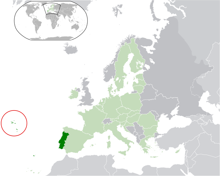
The Virgin Islands of the United States (commonly called the United States Virgin Islands, U.S. Virgin Islands or USVI) are a group of islands in the Caribbean that are an insular area of the United States. The islands are geographically part of the Virgin Islands archipelago and are located in the Leeward Islands of the Lesser Antilles.

The U.S. Virgin Islands consist of the main islands of Saint Croix, Saint John, and Saint Thomas, along with the much smaller but historically distinct Water Island, and many other surrounding minor islands. The total land area of the territory is 133.73 square miles (346.4 km2).[1]

As of the 2010 census the population was 106,405,[3] mostly composed by those of Afro-Caribbean descent. Tourism is the primary economic activity, although there is a significant manufacturing sector.[1]

Formerly the Danish West Indies, they were sold to the United States by Denmark in the Treaty of the Danish West Indies of 1916. They are classified by the UN as a Non-Self-Governing Territory, and are currently an organized, unincorporated United States territory. The U.S. Virgin Islands are organized under the Revised Organic Act of 1954, and have since held five constitutional conventions. The last and only proposed Constitution adopted by the Fifth Constitutional Convention in 2009 was rejected by the U.S. Congress in 2010, which urged the convention to reconvene to address the concerns Congress and the Obama administration have had with the proposed document. The convention is slated to reconvene in October 2012 to address these concerns.


アメリカ領ヴァージン諸島(アメリカりょうヴァージンしょとう、United States Virgin Islands)は、西インド諸島にあるアメリカ合衆国の保護領(自治領)。ヴァージン諸島の西側半分。東側は、イギリス領ヴァージン諸島。「島」と呼ばれるのは40程度あるが、ほとんどが無人島である。人が住み、一般の観光客が訪れるような主要な島は、セント・トーマス島 (Saint Thomas)、セント・クロイ島 (Saint Croix)、セント・ジョン島 (Saint John) の3島である。首都は、セント・トーマス島のシャーロット・アマリー。


先日よりよく聞えてきます。
但し、さすがに聞え始めた途端大きなPileへとなりますので
なかなか簡単にはQSOには至りません。
しかしながら、大体の感覚は掴めて来ましたので、
近日中にはGet!!としたいところです。

では、今夜聞えていたKP2/K5WEをお聞きください。

20120919 1035UTC 14002kHz KP2/K5WE


Date : 19/Sep/2012 1035UTC
Freq : 14002kHz CW
Rig : KENWOOD TS-870
ANT : LOOP
PC : recording

Monday, September 17, 2012

CU2CE(Azores Is) on 15m SSB!!

CU2CE(Azores Is) on 15m SSB!!


CU2CE QSL Card  << Click!!


The Archipelago of the Azores (UK /əˈzɔrz/ ə-zorz, US /ˈeɪzɔrz/ ay-zorz; Portuguese: Açores, IPA: [ɐˈsoɾɨʃ]) is composed of nine volcanic islands situated in the North Atlantic Ocean, and is located about 1,500 km (930 mi) west of Lisbon and about 1,900 km (1,200 mi) southeast of Newfoundland. The islands, and their Exclusive Economic Zone, form the Autonomous Region of the Azores, one of the two autonomous regions of Portugal. Its main industries are: agriculture, dairy farming (for cheese and butter products primarily), livestock ranching, fishing and tourism, which is becoming the major service activity in the region. In addition to this, the government of the Azores employs a large percentage of the population directly or indirectly in many aspects of the service and tertiary sectors.
There are nine major Azores islands and an islet cluster, in three main groups. These are Flores and Corvo, to the west; Graciosa, Terceira, São Jorge, Pico and Faial in the centre; and São Miguel, Santa Maria and the Formigas Reef to the east. They extend for more than 600 km (370 mi) and lie in a northwest-southeast direction.


ポルトガル沖約1000kmの大西洋上に浮かぶ。1427年に発見された。リスボンから約1500km、北アメリカの東端から3900kmの位置にある。火山が起源で、九つの島からなる。ピコ島の火山ピコ山は標高2351mでアソーレスのみならずポルトガルの最高地点である。

捕鯨および遠洋漁業の基地としても使われたほか、現在は温暖な気候から保養地として人気がある。


アソーレス諸島の各島(サイズ別)
島名 面積
(km2)
サンミゲル島 759
ピコ島 446
テルセイラ島 403
サンジョルジェ島 246
ファイアル島 173
フローレス島 143
サンタマリア島 97
グラシオーザ島 62
コルヴォ島 17
リスボンのほぼ西に位置する。主要な島は九つ。総面積は2355km2である。気候は一年を通じて温暖である。アソーレス諸島は、大西洋中央海嶺とホットスポットが重複した位置にあり、基本的には、火山島である。

アソーレス諸島の島は、3つに大別される。

東部(葡: Grupo Oriental):サンミゲル島(葡: São Miguel)、サンタマリア島、フォルミガス島。
中部(葡: Grupo Central):テルセイラ島(葡: Terceira)、サンジョルジェ島、ピコ島(葡: Pico)、ファイアル島、グラシオーザ島。
西部(葡: Grupo Ocidental):フローレス島、(葡: Flores)コルヴォ島(葡: Corvo)。
最大の島はサンミゲル島、最小の島はコルヴォ島である。

また、西経25度~31度という位置にあることから、ポルトガル本土やマデイラ諸島よりも1時間遅いUTC-1(夏時間の際にはUTC+0)を標準時として採用している(スペイン本土とカナリア諸島の関係に似ているが、スペインよりも1時間遅れている)。


ここでもJA局の声が聞えています。
録音ファイルの冒頭にはその模様が録音されていたはずですがFailled
人事ながら何故か嬉しく思うのはどんなものか?
※ 1135UTC・・録音ファイル冒頭がAMでした)涙 USBへ変更
もう少し遅い時間がPropagationとしては良いようですね。
一昨日より15mの雰囲気が理解出来始めたようだ。

ではまだ未交信ながらも聞えているCU2CEのDxingをお聞きください。


210917 1134UTC 21250kHz CU2CE


Date : 17/Sep/2012 1134UTC
Freq : 21250kHz USB
Rig : ICOM IC-8500 in Greece
ANT : MDP
PC recording


JX9JKA(Jan Mayen Island) on 15m SSB!!

JX9JKA(Jan Mayen Island) on 15m SSB!! 


JX9JKA QSL card


Jan Mayen Island is a volcanic island in the Arctic Ocean and part of the Kingdom of Norway. It is 55 km (34 mi) long (southwest-northeast) and 373 km2 (144 sq mi) in area, partly covered by glaciers (an area of 114.2 km (71.0 mi) around the Beerenberg). It has two parts: larger northeast Nord-Jan and smaller Sør-Jan, linked by an isthmus 2.5 km (1.6 mi) wide. It lies 600 km (370 mi) northeast of Iceland, 500 km (310 mi) east of central Greenland and 1,000 km (620 mi) west of the North Cape, Norway. The island is mountainous, the highest summit being the Beerenberg volcano in the north. The isthmus is the location of the two largest lakes of the island, Sørlaguna (South Lagoon), and Nordlaguna (North Lagoon). A third lake is called Ullerenglaguna (Ullereng Lagoon). Jan Mayen was formed by the Jan Mayen hotspot.


ヤンマイエン島(ノルウェー語: Jan Mayen)は、グリーンランド東方の北極海に位置するノルウェー領の島。標高2,277mのベーレンベルク山を擁する火山島である。定住者はいないが、電波航法(LORAN)援助施設と気象観測施設があり、ノルウェーの軍と気象局の要員が駐在している。


これは、JW9DLが7月にQRVした時の状況です。
JAからONLINE上から見えているのはJJ5IZX(私)です。
そして、相手はJW9DLへとよく見てみると、Jan Mayen Island ICELAND
にも送信局がいます。
ちょうどGREENLANDの東側ですね。


そのときのPropagationです。
JW9(スバルバード)より
ICELAND GREENLANDが遥かに条件は良いのです。
驚きの事実ですが、実際はこんなもので、単に相手局のActivityが高いと、少々不利でもQSO可能
逆に相手がいなければ、いくら条件が良くてもQSOは不可です。


さて、今回はいつもの20mではなく15mなので、JAからの伝播は?です。
しかし受信中には多くのJA局がTryしておりQSO成立を聞きました。
願わくば私自身も早々にQSOしてみたいですね。
では JX9JKA(Jan Mayen Island)をお聞きください。


210916 1237UTC 21293kHz JX9JKA


Date : 16/Sep/2012 1237UTC 
Freq : 21293kHz USB 
Rig : Kenwood TS-480(in Greece) 
ANT : MDP 
PC recording


Sunday, September 16, 2012

V5/DL3ZAD(Namibia) on 15m SSB!!!

V5/DL3ZAD(Namibia) on 15m SSB!!!


Namibia, officially the Republic of Namibia (Afrikaans: Republiek van Namibië, German:  Republik Namibia (help·info)), is a country in southern Africa whose western border is the Atlantic Ocean. It shares land borders with Angola and Zambia to the north, Botswana to the east and South Africa to the south and east. Although it does not border with Zimbabwe, less than 200 meters of riverbed (essentially the Zambia/Botswana border) separates them at their closest points. It gained independence from South Africa on 21 March 1990, following the Namibian War of Independence. Its capital and largest city is Windhoek. Namibia is a member state of the United Nations (UN), the Southern African Development Community (SADC), the African Union (AU), and the Commonwealth of Nations.
The dry lands of Namibia were inhabited since early times by Bushmen, Damara, and Namaqua, and since about the 14th century AD by immigrating Bantu who came with the Bantu expansion. It became a German Imperial protectorate in 1884 and remained a German colony until the end of World War I. In 1920, the League of Nations mandated the country to South Africa, which imposed its laws and, from 1948, its apartheid policy.


ナミビア共和国(ナミビアきょうわこく)、通称ナミビアは、アフリカ南西部に位置する共和制国家で、イギリス連邦加盟国である。北にアンゴラ、北東にザンビア、東にボツワナ、南に南アフリカ共和国と国境を接し[2]、西は大西洋に面する。首都はウィントフック。

当初ドイツ(一部イギリス)が植民地とし、植民地時代の名称は南西アフリカ。第一次世界大戦以後は南アフリカ連邦が委任統治を足がかりに国際法上違法な併合を行った。その後、1990年に独立を達成している。南アフリカ共和国の統治時代には人種隔離政策が行われ、バントゥースタン(ホームランド)が置かれた。


コールサインの通り、運用局はDL3ZAD
聞いての通りFBなシグナルです。
Namibiaの信号は6月くらいでしょうか?
同じく15mCWでの信号を聞いたくらいでしょうか
久しぶりの受信となります。
※ これだけクリアに聞えていると嬉しくなってきます。


さて西日本では台風の影響にて、相当風が強く我家のアンテナが壊れてしまいそうです。
本日アンテナを降ろし、様子見をしているところです。
とは言え、このままでは面白くないのでSWL化したところです。

210916 0753UTC 21275kHz V5/DL3ZAD


Date : 16/Sep/2012 0753UTC 
Freq : 21275kHz USB 
Rig : ICOM IC-8500(in Itly) 
ANT : MDP 
PC recording

P49T(Aruba) on 40m LSB!!

P49T(Aruba) on 40m LSB!!


Aruba (play /əˈrbə/ ə-roo-bəDutch pronunciation: [aˈruba]) is a 33-kilometer-long island (20 mi) of the Lesser Antilles in the southern Caribbean Sea, located 27 km (17 mi) north of the coast of Venezuela and approximately 130 km (81 mi) east ofGuajira Peninsula (Colombia). Together with Bonaire andCuraçao, it forms a group referred to as the ABC islands of theLeeward Antilles, the southern island chain of the Lesser Antilles. Aruba and all the Dutch islands in the Antilles together, are commonly referred to as the Netherlands Antilles (or the Dutch Antilles).
Aruba is one of the four constituent countries that form theKingdom of the Netherlands, together with the Netherlands,Curaçao, and Sint Maarten whose citizens share a single nationality: Dutch citizen. Aruba has no administrative subdivisions, but for census purposes is divided into eight regions. Its capital is Oranjestad.
Unlike much of the Caribbean region, Aruba has a dry climate and an arid, cactus-strewn landscape. This climate has helped tourism as visitors to the island can reliably expect warm, sunny weather. It has a land area of 179 square kilometres (69.1 sq mi) and is densely populated with a total of 101,484 inhabitants at the 2010 Census. It lies outside the hurricane belt.


アルバオランダ語Aruba)は、西インド諸島の南端部、南米ベネズエラの北西沖に浮かぶ島。高度な自治が認められたオランダ王国構成国。本土オランダキュラソーシント・マールテンと共に対等な立場でオランダ王国を構成している。

アルバの最初の住民は、アラワク部族のカケティオス・インディアンである。彼らは、カリブ族による攻撃から逃れて、ベネズエラからこの地に移住した。最古のインディアン住居跡は、西暦1000年頃までさかのぼる。他の西インド諸島とも距離もあり、海の高い波はカヌーでの航海を困難にしたため、カケティオスたちはカリブ海よりも南米に多く見られた。
スペイン人探検家のアロンソ・デ・オヘダ (Alonso de Ojeda) は、1499年頃、最初のヨーロッパ人として同地に到着したと考えられているが、開拓地は建設されなかった。多くのほかの西インド諸島と異なり、プランテーションはアルバでは発達しなかった。その代わりにスペイン人は、多くのカケティオスをイスパニョーラ島へ送り、そこで奴隷として掘削の仕事を強制した。
1636年、アルバはオランダに承認され、2世紀近くオランダの植民地支配下にあった。1805年以降のナポレオン・ボナパルトによる戦争の間、イギリスが主に島の植民地支配をしたが、1816年に再びオランダの植民地支配に戻された。
19世紀のゴールドラッシュで繁栄した。最初の原油積み替え施設が1924年に、1928年には製油所が開設された。これはアメリカ合衆国スタンダード・オイル・オブ・ニュージャージー(現在のエクソンモービル)の100%出資の子会社、ラゴ・オイル&トランスポート株式会社 (Lago Oil & Transport Co. Ltd.) である。
ラゴ製油所は島の東端に位置し、西端にはロイヤル・ダッチ・シェルが小さい「イーグル製油所」を保持していたが、第二次世界大戦勃発後のオランダのドイツによる占領のすぐ後に閉鎖を余儀なくされた。
第二次世界大戦後の1954年に、オランダ領アンティル)の一部()に組み込まれたが、1986年単独の自治領()として分離した。現在に至るまでオランダの統治下にある。


W3BTX and W3TEF will be active from Aruba 14-21 September 2012 
as P49T ( P49Towers 9/11 Special Event Station)
They will be active on HF Bands
QSL via W3BTX direct , buro 


大規模なシステムをお持ちのOMさんならいざ知らず、
私のような弱小局には聞えるハズもない。
でもClusterに出てくる以上興味はある。
そこでOnline_Receiverを使ってみた。
RX QTH  kentucky
Rig    ICOM IC-706MK2
どうだろう?
底氏聞き取り辛いような気もするが、
取りあえず大Pileupを受信した。


本日(9月16日 日本時間午前10時06分)の録音です。
ほんの1時間ほど前の出来事です。
地球丸く、ここ日本では聞えない信号もこういった状況なのです。

では、P49T vs USA stationsのBattleをお聞きください。


Date : 16/Sep/2012 0116UTC 
Freq : 7130kHz LSB 
Rig : ICOM IC-706MK2(in kentucky) 
ANT : DP 
PC recording

Tuesday, September 11, 2012

ZD7VC(St Helena Island) on 20m RTTY!!

ZD7VC(St Helena Island) on 20m RTTY!!


St Helena Island


セントヘレナSaint Helena)は、南大西洋に浮かぶイギリス領の火山島アフリカ大陸から 2,800 km 離れた孤島で、人口は約4,000人。ナポレオン1世幽閉の地として知られる。
行政上はイギリスの海外領土セントヘレナ・アセンションおよびトリスタンダクーニャに属する一区域で、その中心地である。島の中心集落であるジェームズタウンは、この海外領土の首府である。
アフリカ大陸西岸より 2,800 km 離れている。ギネスブックによると「地球上で他の陸地から距離が2番目に遠い陸地」とされる(最も遠い陸地はイースター島)。スエズ運河完成まではインド洋に向かう航路上の要衝であり、給水地として用いられた。また、絶海の孤島であることから流刑地として用いられた。
火山島で最高峰がダイアナ山(820m)である。島の周囲は断崖が多い。
絶海の孤島であるため流刑地として使用され、ナポレオン1世の流刑地として著名である。このことは現在、島の観光経済に大きく寄与している。またボーア戦争後にもボーア側首脳の流刑地として使用された。

Saint Helena
 (play /ˌsnt həˈlnə/ saynt-hə-lee-nə), named afterSaint Helena of Constantinople, is an island of volcanic origin in the South Atlantic Ocean. It is part of the British overseas territory of Saint Helena, Ascension and Tristan da Cunha[3]which also includes Ascension Island and the islands of Tristan da Cunha. Saint Helena measures about 16 by 8 kilometres (10 by 5 mi) and has a population of 4,255 (2008 census).[2]
The island was uninhabited when discovered by the Portuguesein 1502. It is one of the most isolated islands in the world. For centuries, it was an important stopover for ships sailing to Europe from Asia and South Africa. The British also used the island as a place of exile, most notably for Napoleon IDinuzulu kaCetshwayo and more than 5,000 Boer prisoners. Saint Helena is Britain's second oldest remaining colony (now termed overseas territory), after Bermuda.

Radio

Radio St Helena, which started operations on Christmas Day 1967, provides a local radio service that has a range of about 100 km from the island, and also broadcasts internationally on Shortwave Radio (11092.5 kHz) on one day a year.[31] The station presents news, features and music in collaboration with its sister newspaper, the St Helena Herald. As of 2012, the station is set to go off the air permanently, giving way to a new three-channel FM station run by the St. Helena Broadcasting Corporation.[32]
Saint FM[33] provides a local radio service for the island which is also available on internet radio[34] and relayed in Ascension Island. The station is not government funded. It was launched in January 2005. It broadcasts news, features and music in collaboration with its sister newspaper, the St Helena Independent.

Radio St HelenaはBCLファンにとっては重要な放送局です。
今は年に一回放送されるか否か・・・
そろそろ季節柄この話題が多く上ってくることでしょう。


Radio St Helena 15-12-2007 to Europe


RX: YAESU FT-1000MP
シグナルは強くないものの非常にクリアです。
これが日本だとなかなか旨くないでしょう。
しかし、時には予想を裏切った伝播があるものです。
「夏枯れ」と言われるお盆の頃ですが、ZD7VCとQSOに成功しました
下記はその頃に受信したZD7VCのQSOの模様です。
RXのみならず2wayQSOの難しさはTryした者にしか判らないでしょう。
では、多くのJA局がQSO成功の様子をお聞きください。

20120815 2054UTC 14089kHz ZD7VC


Date : 15/Aug/2012 0917UTC 
Freq : 14089kHz RTTY
Rig : ICOM IC-7200 
ANT : LOOP 
PC recording


Monday, September 10, 2012

HC2/AL1O( Ecuador ) on 20m CW!!


HC2/AL1O( Ecuador ) on 20m CW!!


以前はBCL以外でこの方面の信号を聞いたことがなかったのですが
現在のSystemになってから出てくれば聞える程度になってきました。
と言ってもそれなりのDX局には変わりありません。
半月ほど古いDATAですが、最近Blogが好評?らしいのでUPします。
※ 下記はHC2/AL1Oの運用者DH1TWのDATAを参照しています。


Tobias Wellnitz氏


Albertos great Station with Monoband antennas from 10m to 160m. Usually the group of HD2A operate from the station. If you hear them the next time, give them a call!

写真を大きくしていただけると納得です。
すばらしいSystemです。


HC2/AL1O qrv from Ecuador

 During my stay in Ecuador I was able to operate two days under my US Callsign as HC2/AL1O. Special thanks to my host Alberto, HC2AQ who offered me his shack. Within two days, 1700 QSOs found their way into the log.
 Read on for pictures, online log & QSL information.

Operation

During my stay I tried to work on all bands from 10m down to 80m. I had great pileups on 15m and 20m from JA and the US. In the evening I enjoyed very much the operation on 80m CW. During the time of the European sunrise (06:00Z – 08:00Z) I worked EU, NA, JA and ZL at the same time!

Online Log & LoTW

Thanks to everyone who gave me a call. The check your callsign in the online log below. The log will soon be submitted to LOTW as well.
Check out the Log & request your QSL card here

QSL Cards

In case you are interested in a QSL card please request it through the Clublog OQSL system. The more expensive way is to send it to my address. If you can wait, then send it through the buro via my German Callsign DH1TW.

DATAからはHK2AのHome Stationからの運用ですね。
確かにHK2AはコンテストStationとしては常連局で
日本にもその信号は楽々と届いています。

では今回受信した状況をいつものように公開いたします。
束の間のDxtimeをどうぞ。

20120819 0758UTC 14001kHz HC2/AL1O


Date : 19/Aug/2012 0758UTC 
Freq : 14001kHz CW 
Rig : ICOM IC-7200 
ANT : LOOP 
PC recording

いかがでしたでしょうか?
QSOの記録はまだまだありますので、順次公開していく予定です。

Sunday, September 9, 2012

KH0R(Mariana Is) on 20m CW!!

KH0R(Mariana Is) on 20m CW!!


調べてみると日本人が運用している
Adminは「JE6DND」局
詳細はQRZ.comを参照してください。


マリアナ諸島(Mariana Islands)はミクロネシア北西部の列島。東の北西太平洋と西のフィリピン海の境界に位置し、北には小笠原諸島、南にはカロリン諸島がある。南北約800キロメートルに連なる約15の島から構成され、北緯13度から21度、東経144度から146度の間に弧状に広がっている。
南端のグアム島を除く島々を北マリアナ諸島サイパン島より北の島々を北部諸島(Northern Mariana Islands)と呼ぶ。
全域がアメリカ合衆国領である。ただし、グアムと北マリアナ諸島は別の行政区画である。地位も違い、グアムは準州、北マリアナ諸島は米国自治連邦区(コモンウェルス)である。
人口は2000年の調査では22万426人。うちグアム島が15万4805人、北マリアナ諸島が6万9,221人。北マリアナ諸島のうちロタ島が3283人、テニアン島が3540人、サイパン島が6万2392人、北部諸島が6人。


The Mariana Islands (also the Marianas; up to the early 20th century sometimes calledLadrones Islands, from SpanishIslas de los Ladrones meaning "Islands of Thieves") are an arc-shaped archipelago made up by the summits of fifteen volcanic mountains in the north-westernPacific Ocean between the 12thand 21st parallels north and along the 145th meridian east. They are south of Japan and north of New Guinea, and form the eastern limit of the Philippine Sea. The islands were named after Spanish QueenMariana of Austria in the 17th century, when Spain started the colonization of the archipelago. They form the northern part of the western Pacific subregion ofMicronesia, and are composed of two U.S. jurisdictions: the Commonwealth of the Northern Mariana Islands and, at the southern end of the chain of islands, the territory of Guam.
The islands are part of a geologic structure known as the Izu-Bonin-Mariana Arc system, and range in age from 5 million years old in the north to 30 million years old in the south (Guam). The island chain arises as a result of the western edge of the Pacific Plate moving westward and plunging downward below the Mariana plate, a region which is the most volcanically active convergent plate boundary on Earth. This subduction region, just east of the island chain, forms the noted Mariana Trench, the deepest part of the Earth's oceans and lowest part of Earth's crust. In this region, according to geologic theory, water trapped in the extensive faulting of the Pacific Plate as serpentinite, is heated by the higher temperatures of depth during its subduction, and the pressure from the expanding steam results in the hydrothermal activity in the area, and the volcanic activity which formed the Mariana Islands.[1]
Frim Wiki


本日は日曜日、にわか雨が降り始めた途端
Clusterに「K50R」? どこだ?
取りあえず確認してみよう
ああ 「KH0R」(Mariana Is)だ。
どうりで信号が強力なはずだ。
下の録音ファイルを聞いて頂けると理解できると思う。

どこかの掲示板でも同様な事を言ってる人たちがいる
皆、同じ事を考えるんだね 笑

20120909 1039UTC 14015kHz KH0R


Date : 05/Sep/2012 0917UTC 
Freq : 14050kHz CW 
Rig : ICOM IC-7200 
ANT : LOOP 
PC recording