LY2IJ
ARUNAS VAGLYS
P.O.BOX 1573 VILNIUS - 40 LT-10011 Lithuania [+] Mailing label | ||
Lookups: 34182 Ham Member
| ||
| Email: | ||
20130320 1124UTC 10103kHz FS/LY2IJ
Date : 20/Mar/2013 1124UTC
Freq : 10103kHz CW
Rig : SDR(PI4THT)
ANT : Mini-Whip(PAØRDT)
PC recording
Very weak sig..but Ican read!!!
Saint Martin
From Wikipedia, the free encyclopedia
For other uses, see St. Martin (disambiguation).
| Native name: Sint Maarten (Dutch) Saint-Martin (French) Nickname: The Friendly Island | |
|---|---|
 | |
 | |
| Geography | |
| Location | Caribbean Sea |
| Coordinates | 18°04′N 63°03′WCoordinates: 18°04′N 63°03′W |
| Archipelago | Leeward Islands, Lesser Antilles |
| Area | 87 km2 (33.6 sq mi) |
| Highest elevation | 414 m (1,358 ft) |
| Highest point | Pic Paradis |
| Sovereignty | |
| French Republic | |
| Overseas collectivity | |
| Capital city | Marigot |
| Largest city | Marigot (pop. 5,700) |
Kingdom of the Netherlands
| |
| Constituent country | |
| Capital city | Philipsburg |
| Largest city | Lower Prince's Quarter (8,123) |
| Demographics | |
| Demonym | St. Martiner (French); St. Maartener (Dutch) |
| Population | 77,741 (as of January 1, 2009) |
| Density | 892 /km2 (2,310 /sq mi) |
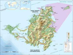
Saint Martin (French: Saint-Martin; Dutch: Sint Maarten) is an island in the northeastCaribbean, approximately 300 km (190 mi) east of Puerto Rico. The 87 km2 island is divided roughly 60/40 between France (53 km2)[1] and the Kingdom of the Netherlands (34 km2);[2]however, the Dutch side has the larger population. It is one of the smallest sea islands divided between two nations, a division dating to 1648. The southern Dutch part comprises Sint Maarten and is one of four constituent countries that form the Kingdom of the Netherlands. The northern French part comprises the Collectivité de Saint-Martin (Collectivity of St. Martin) and is an overseas collectivity of France.
On January 1, 2009 the population of the entire island was 77,741 inhabitants, with 40,917 living on the Dutch side,[3] and 36,824 on the French side.[4]
Collectively, the two territories are known as "St-Martin / St Maarten". Sometimes SXM, theIATA identifier for Princess Juliana International Airport (the island's main airport), is used to refer to the island.
Geography
Saint Martin has a land area of 87 km2, 53 km2 of which is under the sovereignty of France,[1]and 34 km² under the sovereignty of the Kingdom of the Netherlands.[2]
The main cities are Philipsburg (Dutch side) and Marigot (French side). While the city with the highest population, Marigot, lies on the French side, the Dutch side is more heavily populated overall.
The highest hilltop is the Pic Paradis (424 m) on center of a hill chain (French side). But both sides are hilly with large mountain peaks. This forms a valley were many houses are located. There are no rivers on the island, but many dry guts. Hiking trails give access to the dry forestcovering tops and slopes.
Under the Köppen climate classification, the island has a tropical monsoon climate with a dry season from January to April and a rainy season from August to December.[5] The precipitation patterns are due to the movement of the Azores high during the year.[5] With the wind direction predominantly from the east or the northeast, temperatures remain stable throughout the year and temperatures rarely exceed 34 °C (93 °F) or fall below 20 °C (68 °F).[5] Temperatures remain steady throughout the year with an average mean temperature of 27.2 °C (81.0 °F). The average sea temperature is27.2 °C (81.0 °F) ranging from a low of 25.9 °C (78.6 °F)in February to a high of 28.4 °C (83.1 °F) in October.[6]The total average yearly rainfall is 1,047 mm (41.2 in), with 142 days of measureable rainfall.[6] Thunderstorms can occasionally occur with 18 days with thunder per year.[6]
The island is located south of Anguilla, separated from the British territory by the Anguilla Channel. Saint Martin is northwest of Saint Barthélemy, separated from the French territory by the Saint-Barthélemy Channel.


