Tuesday, January 29, 2013

3W7W(Vietnam) on 20m USB!!!

3W7W(Vietnam) on 20m USB!!!


3W7W  Vietnam flag Vietnam 
Wayne Peterson
12 Ba Lang Duong
Nha Trang
Vietnam

[+] Mailing label
Lookups:   17410 XML Subscriber
Email: Use mouse to view.. QSL: LOTW, W3HNK, EQSL


20130129 1052UTC 14195kHz 3W7W
Date : 29/Jan/2013 1052UTC 
Freq : 14195kHz USB
Rig  : ICOM IC-7200
ANT  : LOOP
PC recording


QSL via W3HNK or LotW.

Location: Nha Trang City, a coastal beach city.
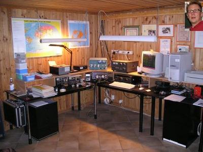
Transciever: Kenwood TS950SDX w/Heil BM-10 headset (HC-4).
Amplifier: Heathkit SB-220 @1000w using (2) Siemens RS1002s, 4-400A equivs.
Antenna: Cushcraft A3S tribander for 10-15-20 at 18 mtrs AGL and a 1/4 wave vertical for 40 mtrs.

Please QSL via W3HNK or LotW (pse no direct QSLs)I now confirm QRZ.com contacts. Sorry for the delay.

The XYL and I live here in Nha Trang December through May and California the remaining 6 months. We are located directly next to the South ChinaSea. The 3rd floor deck provides a perfect place to mount a tower or mast for the A3S and 40m vertical.
Most frequently,3W7W will be around 14.200. The QRN is high here so I do have a problem hearing weaker signals.
The XYL's family are all here in Nha Trang. She used to visit them from California every year for 2 months so I thought it would be better to just come live here part time. So, she designed our house-to-be, with a few inputs from me of course, gathered up her design plans and came here in 2009 to oversee the construction.
I was originally licensed as KN6ZSJ in 1956. Later I held the call of DJ0QF in the late 1960s while working for Siemens in Munich and still speak German.
73, Wayne 3W7W (K6ZSJ)

Lookups17410 (21724)
QRZ Admin3W7W
Last Update2012-10-30 20:57:28
Classex
Latitude12.283849 (12° 17' 1'' N)
Longitude109.203196 (109° 12' 11'' E)
Grid SquareOK42og
Geo SourceUser supplied
Bearing232.6° SW (from JJ5IZX)
Distance2138.3 mi (3441.2 km)
Long Path22718.6 mi (36562.0 km)
Sunrise23:08:54 UTC
Sunset10:43:18 UTC
ITU Zone49
CQ Zone26
Born1939
QSL InfoLOTW, W3HNK, EQSL
QSL by Mail?No (e.g. Will this ham QSL by Postal Mail?)
QSL by eQSL?Yes (e.g. Will this ham QSL with eQSL?)
Uses LOTW?Yes (e.g. Does this ham use ARRL's LOTW ?)
Admin For(2) 3W7W K6ZSJ
Other
Callsigns
AliasComment
K6ZSJex- XV7ZSJ Grid Sq. OK42og
Apply for a new Vanity callsign...

JG8NQJ/JD1(Minami Torishima) on 20m CW!!!

JG8NQJ/JD1(Minami Torishima) on 20m CW!!!

JG8NQJ Minami Torishima flag Minami Torishima 
Take JG8NQJ/JD1
Marcus Island
DO NOT SEND YOUR QSL TO THIS ADDRESS!
Minami Torishima

[+] Mailing label
Lookups:   19987
QSL: CHECK JA8CJY FOR DETAILS

20130129 1009UTC 14045kHz JG8NQJ/JD1
Date : 29/Jan/2013 1009UTC 
Freq : 14045kHz CW
Rig  : ICOM IC-7200
ANT  : LOOP
PC recording

Tnx fer QSO 73's : )


JG8NQJ will be active from Marcus Island , Minami Torishima Islands (IOTA OC-073) as JG8NQJ/JD1

NEVER SEND YOUR QSL(s) TO MARCUS ISLAND ADDRESS ABOVE!!

Logsearch JG8NQJ / JD1


Minami-Tori-shima (南鳥島) or Marcus Island is an isolated Japanese coral atoll in the northwestern Pacific Ocean, located some 1,848 kilometres (1,148 mi) SE of former Tokyo City and 1,267 kilometres (787 mi) east of the closest Japanese island, South Iwo Jima of the Ogasawara Islands, and nearly on a straight line between mainland Tokyo and US' Wake Island, which is 1,415 kilometres (879 mi) east southeast. The closest island, however, is theEast Island of the Maug Islands of the Mariana Islands, which is 1,015 kilometres (631 mi) west south-west of Minami-Tori-shima. The meaning of the Japanese name is "Southern Bird Island". It is the easternmost territory belonging to Japan, and the only Japanese territory on the Pacific Plate, past the Japan Trench. Although very small, it is of extreme strategic importance, as it enables Japan to claim a 428,875 square kilometres (165,589.6 sq mi) Exclusive Economic Zone in the surrounding waters. It is also the easternmost territory of Tokyo, being administratively part of Ogasawara village.


Geography

Minami-Tori-shima is triangular in shape, and unusual in that it has an inverted-saucer like profile, with a raised outer rim of between 5 and 9 metres (16 and 30 ft) above sea level. The central area of the island is 1 metre (3 ft) below sea level. Minami-Tori-shima is surrounded by a fringing reef which ranges from 50 to 300 metres (164–984 ft) in width, enclosing a shallow lagoon, which is connected with the open ocean by narrow passages on the southern and northeastern sides. Outside the reef, the ocean depths quickly plunge to over 1,000 metres (3,300 ft). The island has a total land area of 1.2 square kilometres (300 acres). The island also has the highest average temperature in Japan.[1]


D44TIB(Cape Verde) on 20m CW!!!

D44TIB(Cape Verde) on 20m CW!!!


D44TIB – Cape Verde
FRIDAY JAN 25, 2013

Mats, SM7GIB will be active holiday-style as D44TIB from Cape Verde between February 25 to March 8, 2013.
QRV with a wire vertical on 160-10m.
QSL via H/c.


SM7GIB Sweden flag Sweden 
MATS OLOFSSON
VARBYANGEN 28
BARA SE-23040
Sweden

[+] Mailing label
Lookups:   6638 Ham Member
Email: Use mouse to view.. QSL: ADMIN: SM4GIB, SC7DX, SV5/SM7GIB, EA8/SM7GIB

20130129 1000UTC 14013kHz D44TIB
Date : 29/Jan/2013 1000UTC 
Freq : 14013kHz CW
Rig  : SDR(PI4THT)
ANT  : Mini-Whip(PAØRDT)
PC recording

Heavy QRM... : (


CX6DZ(Urguay) on 20m USB-2!!!

CX6DZ(Urguay) on 20m USB-2!!!


CX6DZ Uruguay flag Uruguay 
OMAR GABRIEL BOLLA RODRIGUEZ
Picaflores mz 139 s 4
Montes de Solymar Canelones 15050
Uruguay

[+] Mailing label
Lookups:   16225 Ham Member
Email: Use mouse to view.. QSL: :DIRECT,MY QSL CARD MAY BE SENT DIRECTLY ONLY


20130129 0944UTC 14208kHz CX6DZ

Date : 29/Jan/2013 0944UTC 
Freq : 14208kHz USB
Rig  : ICOM IC-7200
ANT  : LOOP
PC recording


 +598299350201 (099350201)


TRABAJAMOS AHORA CON UN KENWOOD 940S Y MIC YAESU MD 100 LINEAL HEATHKIT SB-200 1000W ANTENA DE 8 ELEM YAGI 25MT DE ALTURA .

Now works with a Kenwood 940, MICROPHONEMD 100 YAESU, Heathkit LINEAR 1000W, and8 elem log periodicownconstruction designof the2010aslYagi, 10m,11m,12m,15,17m,20m

25 m high

have thecardsin no timewe arestrengthening allthank you all forwaiting
tenemos las tarjetas , en poco tiempo estamos confirmando a todos gracias a todos por esperar
My QSL card may be sent directly only .Please include SAE and 3 GS or 2 IRC .FOR DIRECT QSL US$ 3

include with your QSL Card
By direct post(in america) =minimum 2 US$ or 1,70 Eur
By direct post(outsideEurope, Asia, Oceania, and other country) = minimum 3 US$


1 IRC = us$ 1,50  at Postal Service
a coupon is not enough to pay the expenses of mail


I am a supporter of theDX Code of Conduct:
I will listen, and listen, and then listen again before calling.
I will only call if I can copy the DX station properly.
I will not trust the DX cluster and will be sure of the DX station's call sign before calling.
I will not interfere with the DX station nor anyone calling and will never tune up on the DX frequency or in the QSX slot.
I will wait for the DX station to end a contact before I call.
I will always send my full call sign.
I will call and then listen for a reasonable interval. I will not call continuously.
I will not transmit when the DX operator calls another call sign, not mine.
I will not transmit when the DX operator queries a call sign not like mine.
I will not transmit when the DX station requests geographic areas other than mine.
When the DX operator calls me, I will not repeat my call sign unless I think he has copied it incorrectly.
I will be thankful if and when I do make a contact.
I will respect my fellow hams and conduct myself so as to earn their respect.

IMPORTANT:PLEASE NOTE THAT I NEED US$ 3 OR 2 IRC (not old irc´s please!) TO RETURN DIRECT TO YOU MY QSL CARD. IF I CANNOT COVER FULL MAIL COSTS WITH YOUR SASE, I WILL SEND BY BUREAU.


Lookups16225 (22036)
QRZ AdminCX6DZ
Last Update2012-03-13 12:45:45
Latitude-34.811427 (34° 48' 41'' S)
Longitude-55.943288 (55° 56' 35'' W)
Grid SquareGF25ae
Geo SourceUser supplied
Bearing102.0° ESE (from JJ5IZX)
Distance11867.7 mi (19099.2 km)
Long Path12989.1 mi (20904.0 km)
Sunrise08:47:51 UTC
Sunset22:59:28 UTC
ITU Zone14
CQ Zone13
Born0132
QSL Info:DIRECT,MY QSL CARD MAY BE SENT DIRECTLY ONLY
QSL by Mail?No (e.g. Will this ham QSL by Postal Mail?)
QSL by eQSL?No (e.g. Will this ham QSL with eQSL?)
Uses LOTW?No (e.g. Does this ham use ARRL's LOTW ?)
Admin For(2) CX3AAS CX6DZ
Apply for a new Vanity callsign...

ZK3T(Tokelau Islands) on 20m CW!!!

ZK3T(Tokelau Islands) on 20m CW!!! 

ZK3T Tokelau Islands flag Tokelau Islands 
Dieter DJ2EH
January
2013 DXpedition
Tokelau Islands

[+] Mailing label
Lookups:   7539
QSL: VIA DJ2EH

20130129 0928UTC 14006.3kHz ZK3T

Date : 29/Jan/2013 0928UTC 
Freq : 14006.3kHz CW
Rig  : SDR(PI4THT)
ANT  : Mini-Whip(PAØRDT)
PC recording

Wow come here!!! He is not Pirate.. OK

QSL  DJ2EH


Lookups7539 (22788)
QRZ AdminW3UR
Last Update2013-01-27 17:48:24
Latitude-9.210560 (9° 12' 38'' S)
Longitude-171.958008 (171° 57' 28'' W)
Grid SquareAI40as
Geo SourceUser supplied
Bearing119.5° ESE (from JJ5IZX)
Distance4615.9 mi (7428.5 km)
Long Path20241.0 mi (32574.7 km)
Sunrise17:25:19 UTC
Sunset05:56:28 UTC
ITU Zone62
CQ Zone31
QSL InfoVIA DJ2EH
QSL by Mail?No (e.g. Will this ham QSL by Postal Mail?)
QSL by eQSL?No (e.g. Will this ham QSL with eQSL?)
Uses LOTW?No (e.g. Does this ham use ARRL's LOTW ?)
Apply for a new Vanity callsign...


CT3AS(Madeira Islands) on 20m CW!!!

CT3AS(Madeira Islands) on 20m CW!!!


CT3AS Madeira Island flag Madeira Island 
Ben B. MUELLER
P.O.Box 6
D-29387 Bad Bodenteich
Germany

[+] Mailing label
Lookups:   53146 Ham Member
QSL: VIA DL3BK

20130129 0908UTC 14003.9kHz CT3AS
Date : 29/Jan/2013 0908UTC 
Freq : 14003.9kHz CW
Rig  : SDR(PI4THT)
ANT  : Mini-Whip(PAØRDT)
PC recording

pseQSL via German DL-bureau DARC "CT3AS via DL3BK"!!!

please do not QSLvia CT bureau! These QSLs are not forwarded to me !!!
If QSLs do not cover sufficient postage they will be confirmed via the DARC-bureau !
- direct QSL EU & DX = SASE + 2 greenstamps [ mail / air mail EU & WW fm DL = € 0.75 ]
( Changed fm € 0.55 to now € 0.58 - for  DL in 2013 ! )
- IRCs NOT accepted !!! No chance to use them in DL anymore - SORRY !!!
LOTW: CT3ASVK6FOC, DL3BK - [ updated until 07 JAN 2013 ]
- ex[ DJ8FW, CT3/DJ8FW, OZ/DJ8FW, ZK1XBM]


Lookups53146 (62309)
QRZ AdminCT3AS
Last Update2012-07-23 14:25:57
ClassA
Latitude32.646706 (32° 38' 48'' N)
Longitude-16.827769 (16° 49' 39'' W)
Grid SquareIM12op
Geo SourceUser supplied
Bearing334.5° NNW (from JJ5IZX)
Distance7487.1 mi (12049.3 km)
Long Path17369.7 mi (27953.9 km)
Sunrise08:04:19 UTC
Sunset18:36:16 UTC
ITU Zone36
CQ Zone33
IOTAAF-014 Madeira Archipelago
Born1943
QSL InfoVIA DL3BK
QSL by Mail?Yes (e.g. Will this ham QSL by Postal Mail?)
QSL by eQSL?No (e.g. Will this ham QSL with eQSL?)
Uses LOTW?Yes (e.g. Does this ham use ARRL's LOTW ?)
Admin For(3) CT3AS DL3BK VK6FOC
Apply for a new Vanity callsign...