Monday, December 3, 2012

E51TLA(South Cook Is) on 30m CW!!!

E51TLA(South Cook Is) on 30m CW!!!


E51TLA South Cook Islands flag South Cook Islands Henrik Moller
Vesteralle 10
DK-6840 Oksbol
Denmark

[+] Mailing label
Lookups:   14041
Email: oz6tl@mail.dk QSL: OZ6TL AND LOTW


   2006 - 2007 - 2009 - 2010 - 2011 as E51TLA
   1999 - 2000 - 2001 - 2002 - 2003 as ZK1TLA


20121203 0750UTC 10116kHz E51TLA
Date : 03/Dec/2012 0750UTC 
Freq : 10116kHz CW 
Rig : ICOM IC-7200
ANT : LOOP(for 20m ..not enough gain)
PC recording


The Cook Islands (Listeni/ˈkʊk ˈləndz/Cook Islands MāoriKūki 'Āirani[3]) is a self-governing parliamentary democracy in the South Pacific Ocean in free association with New Zealand. It is composed of 15 small islands whose total land area is 240 square kilometres (92.7 sq mi). The Cook Islands' Exclusive Economic Zone (EEZ), however, covers 1,800,000 square kilometres (690,000 sq mi) of ocean.[4]
The main population centres are on the island of Rarotonga (14,153 in 2006), where there is an international airport. There is a much larger population of Cook Islanders in New Zealand, particularly the North Island. In the 2006 census, 58,008 self-identified as being of ethnic Cook Island Māori descent.[5]
With about 100,000 visitors travelling to the islands in the 2010-11 financial year,[6] tourism is the country's main industry, and the leading element of the economy, far ahead of offshore banking, pearls, and marine and fruit exports.
Defence and foreign affairs are the responsibility of New Zealand, in consultation with the Cook Islands. In recent times, the Cook Islands have adopted an increasingly independent foreign policy. Although Cook Islanders arecitizens of New Zealand, they have the status of Cook Islands nationals, which is not given to other New Zealand citizens.


Geography


Map of the Cook Islands.
The Cook Islands are in the South Pacific Ocean, northeast of New Zealand, between French Polynesia andAmerican Samoa. There are 15 major islands spread over 2.2 million km² of ocean, divided into two distinct groups: the Southern Cook Islands and the Northern Cook Islands of coral atolls.[7]
The islands were formed by volcanic activity; the northern group is older and consists of six atolls, which are sunken volcanoes topped by coral growth. The climate is moderate to tropical.
The 15 islands and two reefs are grouped as follows:


PJ5J(Saba, St Eustatius) on 20m CW!!!

PJ5J(Saba, St Eustatius) on 20m CW!!!


QSL image for PJ5J
PJ5J Saba, St Eustatius flag Saba, St Eustatius 
QSL via JA1HGY - .
.
.
Saba, St Eustatius

[+] Mailing label
Lookups:   6756
QSL: JA1HGY VIA DIRECT OR BUREAU


20121202 2307UTC 14010kHz PJ5J
Date : 02/Dec/2012 2307UTC 
Freq : 14010kHz CW 
Rig : KENWOOD TS-870S 
ANT : LOOP
PC recording


We are pleased to announce that we will be active from PJ5,
the Island of Sint Eustatius known as “Statia or Statius” (IOTA NA-145)
in early December, 2012.
The team consists of seven JA operators, and will be
in the Island between December 1 and December 12.
We have reserved “Keli Keli House” from which Polish team
operated last year and the year before (special tnx to Wlodek/SP6EQZ).
The house is located on the slope of volcano “The Quill”
and has clear view in the direction of AS/NA/EU.
Operator: JA1MZL,JJ1LIB,JN1RVS,JJ1CBY,JA1DXA,JN1HOW and JH1ROJ
Date: December-1st 07:00utc to December-12-2012
Freq: 80m to 6m
Mode: CW SSB and RTTY
PJ5J Log Search
LoTW:
When we received Direct QSL request (OQRS or SASE/$$/IRCs),
Log files will be uploaded by the every week end.
All QSO will be uploaded by the end of January 2013
QSL cards, will be available four ways:
1. OQRS DIRECT (ClubLOG)  Open
    (We pay 43c PayPal charge on every transaction)
2. OQRS BUREAU (ClubLOG)  Open
3. DIRECT MAIL WITH SASE/$$/IRC(s)
4. QSL BUREAU via JA1HGY
But please, use only ONE of the ways to save us a lot of extra work.
Should you choose to QSL directly to JA1HGY via direct mail send your QSO
information (do not need QSL card) and SASE/$$/IRC(s) to:
QSL ROUTE DIRECT:


Sint Eustatius, also known affectionately to the locals as Statia[4] (/ˈstʃə/) or Statius, is a Caribbean island and a special municipality (officially public body) of the Netherlands.[5]
It lies in the northern Leeward Islands portion of the West Indies, southeast of the Virgin Islands and immediately to the northwest of Saint Kitts and Nevis and to the southeast of Saba. The island is named after the legendaryChristian martyr Saint Eustace. The regional capital is Oranjestad.
The island has an area of 21 km² (8.1 sq. miles). In the 2001 census, the population was recorded as 3,543 inhabitants, equating to a population density of 169 inhabitants per square kilometre. The official languages areDutch and English. A local English-based creole is also spoken informally. Travel to the island by air is throughF.D. Roosevelt Airport.
Formerly part of the Netherlands Antilles, Sint Eustatius became a special municipality within the country of the Netherlands on 10 October 2010.[6]
The name of the island "Sint Eustatius" is a reference to Saint Eustace (also spelled Eustachius or Eustathius), a legendary Christian martyr known in Spanish as San Eustaquio and in Portuguese as Santo Eustáquio or Santo Eustácio.


Geography


View looking southeast along the Atlantic coast, showing the airport runway in the middle distance, Lynch Beach beyond that, then the Quill, St. Eustatius' dormant volcano, and over the water in the distance, the northern end of the island ofSt. Kitts.

Sint Eustatius photographed from theISS.
Geographically, the island is saddle-shaped, with the 602 meter-high dormant volcano Quill, (from Dutch kuil, meaning 'pit' - because of its crater) to the southeast and the smaller pair Signal Hill/Little Mountain (or Bergje) and Boven Mountain to the northwest. The Quill crater is a popular tourist attraction on the island. The bulk of the island's population lives in the "dip" between the two areas, which crosses the center of the island.
The national parks of St. Eustatius, comprising the Quill/Boven park, the Botanical Garden, and the Marine Park, are all under the control of the non profit foundation STENAPA.[8]


ZL9HR(Campbell Island New Zealand DXpedition 2012) on 20m CW!!!


ZL9HR(Campbell Island New Zealand DXpedition 2012) on 20m CW!!!


ZL9HR Auckland, Campbell Islands flag Auckland, Campbell Islands Hellenic Amateur Radio Association of Australia Inc.
PO BOX 13 SANS SOUCI
NSW 2219
Australia

[+] Mailing label
Lookups:   6961
QSL: VIA DAVID EB7DX

ZL9HR - Campbell Island New Zealand DXpedition 2012

The Hellenic Amateur Radio of Association of Australia (HARAOA) is organising a DXpedition to ZL9 Campbell Island (OC-037) New Zealand between November 28th and December 9th 2012.
ZL9 Campbell Island NZ is Number 15 on the current DXCC most wanted list.
The Landing Permit has been approved.
More information at www.zl9hr.com


20121202 2156UTC 14035kHz ZL9HR
Date : 02/Dec/2012 2156UTC 
Freq : 14035kHz CW 
Rig : KENWOOD TS-870S 
ANT : LOOP
PC recording


Campbell Island (Motu Ihupuku) is a remoteuninhabitedsubantarctic island of New Zealand and the main island of the Campbell Island group. It covers 112.68 square kilometres (43.51 sq mi) of the group's 113.31 square kilometres (43.75 sq mi), and is surrounded by numerous stacksrocks and islets like Dent IslandFolly Island (or Folly Islands), Isle de Jeanette Marie, and Jacquemart Island, the latter being the southernmost extremity of New Zealand. The Island is mountainous, rising to over 500 metres (1,640 ft) in the south. A long fjordPerseverance Harbour, nearly bisects it, opening out to sea on the east coast.
Campbell Island is inscribed in the UNESCO World Heritage list together with the other subantarctic New Zealand islands in the region as follows: 877-005 Campbell Island S52.33 E169.09 11331 Ha 1998
The island holds the distinction of being the most remote location (on a significant piece of land) from London, England and from Dublin, Ireland.

XV2RZ(Vietnam) on 20m CW!!!

XV2RZ(Vietnam) on 20m CW!!!

XV2RZ Vietnam flag Vietnam Reijo Laitinen
Mantytie 13
76940 Nenonpelto
Finland

[+] Mailing label
Lookups:   129772
Email: xu7mdy@gmail.com QSL: DIRECT ONLY WITH SAE AND 2 USD FOR HIGH POSTAGE


20121202 2328UTC 14025kHz XV2RZ
  Date : 02/Dec/2012 2328UTC 
Freq : 14025kHz CW 
Rig : KENWOOD TS-870S 
ANT : LOOP
PC recording


I will be qrv again from 23rd November to 10th December 2012.
On this time specially digimodes 6-20 m
Good DX'ng
Retu
P.s.
XV2RZ -log is now in:
http://www.clublog.org/index.php
I saw from the DX-cluster that many, many stations have copied me as XU2RZ, XV4RZ,XV1RZ, XV3RZ.
Please, would you check at the first Your qsos that they are ok before the qsl sending!!!!!
If you can't find your callsign from the logs, please ask me by email. I will check then it.
I make this without any financial support, so I am grateful for the feedback I got both on the bands and afterwards.
I feel I have made many hams happy by being their first contact to XV2.
Finally, I wish to express my special thanks to You who have included a little extra in your envelopes.
with cordial thanks
Retu
p.s. I am connected all time into HA6DX-cluster (http://www.hg6n.hu/index.php?option=com_wrapper&view=wrapper&Itemid=118&lang=hu). There you can ask me changing band etc,,,, very quickly.


7P8D(Lesotho) on 20&30m CW!!!


7P8D(Lesotho) on 20&30m CW!!!


7P8D Lesotho flag Lesotho 2012 Lesotho DX pedition 7P8D DX Pedition
P O Box 29169
Sunridge Park 6008
South Africa

[+] Mailing label
Lookups:   40059
Email: Use mouse to view.. QSL: DIRECT AS PER WEBSITE


前回同様、20m用のアンテナなので30mではGain不足。
40mのときと比較するとかなり強いです。
この直前に録音した20mも強かったですが失敗。
UP幅が1kHz以下とは・・・トホホ


20121202 1957UTC 14020kHz 7P8D

Date : 02/Dec/2012 1957UTC 
Freq : 14020kHz CW 
Rig : ICOM IC-7200
ANT : LOOP
PC recording


20121202 2029UTC 10105kHz 7P8D
Date : 02/Dec/2012 2029UTC 
Freq : 10105kHz CW 
Rig : ICOM IC-7200
ANT : LOOP(for 20m not enough gain) 
PC recording


Lesotho (Listeni/lɨˈst/ li-soo-too), officially the Kingdom of Lesotho, is a landlocked country and enclave, completely surrounded by its only neighbouring country, the Republic of South Africa. It is just over 30,000 km2 (11,583 sq mi) in size with a population of approximately 2,067,000.[1] Its capital and largest city is Maseru. Lesotho is a member of the Commonwealth of Nations. The nameLesotho translates roughly into the land of the people who speak Sesotho.[4] About 40% of the population live below theinternational poverty line of US $1.25 a day.[5]


Geography


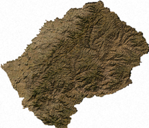
Satellite image of Lesotho

Landscape of Lesotho
Lesotho covers 30,355 km2 (11,720 sq mi). It is the only independent state in the world that lies entirely above 1,000 metres (3,281 ft) in elevation. Its lowest point of 1,400 metres (4,593 ft) is thus the highest in the world. Over 80% of the country lies above 1,800 metres (5,906 ft). Lesotho is also the southernmost landlocked country in the world and is entirely surrounded by the country of South Africa. It lies between latitudes 28° and 31°S, and longitudes 27° and 30°E.

[edit]Climate

Because of its altitude, Lesotho remains cooler throughout the year than other regions at the same latitude. Most of the rain falls as summer thunderstormsMaseru and surrounding lowlands often reach 30 °C (86 °F) in summer. Winters can be cold with the lowlands getting down to −7 °C (19 °F) and the highlands to −18 °C (−0 °F) at times. Snow is common in the highlands between May and September; the higher peaks can experience snowfalls year-round.


Sunday, December 2, 2012

ZP5KO(Paraguay) on 20m CW!!!

ZP5KO(Paraguay) on 20m CW!!!


QSL image for ZP5KO
ZP5KO Paraguay flag Paraguay ROA ATILIO
MECANICOS DE AVIACION 1439
ASUNCION
Paraguay

[+] Mailing label
Lookups:   30136 Ham Member
QSL: ONLY PY4KL


ookups30136 (36387)
QRZ AdminZP5KO
Last Update2010-08-24 23:52:08
Latitude-25.271667 (25° 16' 18'' S)
Longitude-57.626667 (57° 37' 36'' W)
Grid SquareGG14er
Geo SourceUser supplied
Bearing53.1° NE (from JJ5IZX)
Distance11541.8 mi (18574.6 km)
Long Path13315.1 mi (21428.6 km)
Sunrise08:51:53 UTC
Sunset22:27:37 UTC
QSL InfoONLY PY4KL
QSL by Mail?No (e.g. Will this ham QSL by Postal Mail?)
QSL by eQSL?No (e.g. Will this ham QSL with eQSL?)
Uses LOTW?No (e.g. Does this ham use ARRL's LOTW ?)
Admin For(1) ZP5KO
Apply for a new Vanity callsign...


20121202 0725UTC 14025kHz ZP5KO
Date : 02/Dec/2012 0725UTC 
Freq : 14025kHz CW 
Rig : ICOM IC-7200 
ANT : LOOP 
PC recording