Saturday, November 24, 2012

D4C(Cape Verde) on 20m CQ WW CW Contest!!!

D4C(Cape Verdeon 20m CQ WW CW Contest!!!


QSL image for D4C
D4C Cape Verde flag Cape Verde Contest Call
Bureau via IZ4DPV
Direct via IZ4DPV
Cape Verde

[+] Mailing label
Lookups:   145673
Email: info@d4c.cc QSL: BUREAU AND DIRECT VIA IZ4DPV - ALSO LOTW


We finally have found a good on-line engine for log search.

Just click on the " Log Search" menu on the home page of our site (www.d4c.cc), put your call and click "search".
If you are in one of our logs,a small table will appearand will show you where you worked us and in which mode.
If youwish to be more sure about your presence inour logs just fill in the on-line request with full data qso and we will come back toyou.
At this point you will know exactlyfor which qso(s) you can send your direct qsl cards.
If you prefer you can avoid to send your qsl cards, simply request it byfilling the same form and we will give you instructions how to send us a donation to cover qsl expenses (paypaluser only).
Stillvalid the LoTW and EQSL on-line upload logs.
Best 73's
*********************************************************************************
We are now on FB.
please join us on the link https://www.facebook.com/D4C.STATION
Many updates!
*********************************************************************************
If you wish to receive direct QSL CARDS please send us a contribution to cover mail expenses as per following rates:
UPDATED MAIL RATES 2011 May
ITALY 0,60 Euro
EUROPE AND ISRAEL 0,75 Euro (1 USD)
ASIA AND AMERICA 1,60 Euro (2 USD)
AUSTRALIA AND OCEANIA 2,00 Euro (3 USD)
TNX
******************************************************************************* *****
> Written by IK2NCJ > venerdì, 15 agosto 2008 > > IMPORTANT NOTICE:
> > If you ever received return qsl cards sent to D4C via bureau with the print "ARI - NOT MEMBER" please be so kind to send a scan > of it to "info at d 4 c . c c"
> > Direct cards remain processed by usual manager IZ4DPV.
vy 73 Uli DG7LAE
******************************************************************************* *****


20121124 0731UTC 14056.76kHz D4C

Date : 24/Nov/2012 0731UTC 
Freq : 14056.76kHz CW 
Rig : KENWOOD TS-870S 
ANT : LOOP 
PC recording


Cape Verde Listeni/ˌkp ˈvɜrd/ (PortugueseCabo Verdepronounced: [ˈkabu ˈveɾdɨ]), officially the Republic of Cape Verde, is an island country, spanning an archipelago of 10 islands located in the central Atlantic Ocean, 570 kilometres (350 miles) off the coast of Western Africa. The islands, covering a combined area of slightly over 4,000 square kilometres (1,500 sq mi), are of volcanic origin and while three of them (SalBoa Vista and Maio) are fairly flat, sandy and dry, the remaining ones are generally rockier and have more vegetation. However, because of infrequent rainfall, the islands are not particularly green.
The name of the country stems from the nearby Cap Vert, on the Senegalese coast,[5] which in its turn was originally named "Cabo Verde" when it was sighted by Portuguese explorers in 1444, a few years before the islands were discovered (verde is Portuguese for "green").
The previously uninhabited islands were discovered and colonized by the Portuguese in the 15th Century, and became important in the Atlantic slave trade for their location. The islands' prosperity often attracted privateers and pirates, including Sir Francis Drake, a corsair (privateer) under the authority of the British crown, who twice sacked the (then) capital Ribeira Grande, in the 1580s. The islands were also visited by Charles Darwin's expedition in 1832. The decline in the slave trade in the 19th century resulted in an economic crisis for the islands. With few natural resources, and without strong sustainable investment from the Portuguese, the citizens grew increasingly discontent with the colonial masters, who nevertheless refused to provide the local authorities with more autonomy. A budding independence movement culminated in 1975, when a movement originally led by Amílcar Cabral (who was assassinated on 20 January 1973) then passed onto his half-brother Luís Cabral, achieved independence for the archipelago.
The country has an estimated population (most of creole ethnicity) of about 500,000, with its capital city Praiaaccounting for a quarter of its citizens. Nearly 38% of the population lives in rural areas according to the 2010 Cape Verdean census; about 10.6% lives below the poverty threshold, according to the world bank data |2011|, and the literacy rate is around 85%. Politically, the country is a very stable democracy, with notable economic growth and improvements of living conditions despite its lack of natural resources, and has garnered international recognition by other countries and international organizations, which often provide development aid. Since 2007, Cape Verde has been classified as a developing nation.
Tough economic times during the last decades of its colonization and the first years of Cape Verde's independence led many to migrate to Europe, the Americas and other African countries. This migration was so significant that the number of Cape Verdeans and their descendants living abroad currently exceeds the population of Cape Verde itself. Historically, the influx of remittances from these immigrant communities to their families has provided a substantial contribution to help strengthen the country's economy. Currently, the Cape Verdean economy is mostly service-oriented with a growing focus on tourism and foreign investment, which benefits from the islands' warm climate throughout the year, diverse landscape, welcoming people[citation needed] and cultural wealth, especially in music.
C5A(Gambia) on 20m CQ WW CW Contest!!!

C5A(Gambia) on 20m CQ WW CW Contest!!!

C5A The Gambia flag The Gambia DX Expeditions to Gambia of OM0C Contest Team
CQ WW Contests .
QSL via OM2FY
The Gambia

[+] Mailing label
Lookups:   50418
Email: Use mouse to view.. QSL: VIA OM2FY
NEW !!!  curent news on facebook profile:radiosyd c5a contest group

QSL OM2FY

CQ WW DX CW Contest 2010: 27.-28.11. 2010 - QTH: Banjul
CQ WW DX SSB Contest 2011: 29.-30.10. 2011 - QTH: Banjul
CQ WW DX CW Contest 2011: 26.-27.11. 2011 - QTH: Banjul
CQ WW DX SSB Contest 2012: 27.-28.10. 2012 - QTH: Banjul
CQ WW DX CW Contest 2012: 24.-25.11. 2012 - QTH: Banjul


20121124 0742UTC 14059.21kHz C5A

Date : 24/Nov/2012 0742UTC 
Freq : 14059.21kHz CW 
Rig : KENWOOD TS-870S 
ANT : LOOP 
PC recording


The Gambia (the Listeni/ˈɡæmbiə/; officially the Republic of The Gambia), also commonly known as Gambia, is a country in West Africa. Gambia is the smallest country on mainland Africa, surrounded by Senegal except for a short coastline on the Atlantic Ocean in the west.

The country is situated around the Gambia River, the nation's namesake, which flows through the country's centre and empties into the Atlantic Ocean. Its area is 11,295 km² with an estimated population of 1.7 million.
On 18 February 1965, The Gambia gained independence from the United Kingdom and joined the Commonwealth of NationsBanjul is The Gambia's capital, but the largest cities are Serekunda and Brikama.
The Gambia shares historical roots with many other West African nations in the slave trade, which was the key factor in the placing and keeping of a colony on the Gambia River, first by the Portuguese and later by the British. Since gaining independence in 1965, The Gambia has enjoyed relative political stability, with the exception of a brief period of military rulein 1994.[3][4]
Thanks to the fertile land of the country, the economy is dominated by farming, fishing, and tourism. About a third of the population lives below the international poverty line of US$1.25 a day.[5]


Geography


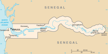
Map of the Gambia
The Gambia is a very small and narrow country whose borders mirror the meandering Gambia River. It lies between latitudes 13° and 14°N, and longitudes 13° and 17°W.
The country is less than 48.2 km (30.0 mi) wide at its widest point, with a total area of 11,295 km². Approximately 1,300 km² of The Gambia's area is covered by water. It is the smallest country on the continent of Africa. In comparative terms The Gambia has a total area which is slightly less than that of the island of Jamaica. The western side of the country borders the North Atlantic Ocean with 50 miles of coastline.[10]
The climate of The Gambia is tropical. There is a hot and rainy season, normally from June until November, but from then until May there are cooler temperatures with less precipitation.[10] The climate in The Gambia is about the same as that found in neighbouring Senegal, southern Mali, and the northern part of Benin.[11]
Its present boundaries were defined in 1889 after an agreement between the United Kingdom and France. During the negotiations between the French and the British in Paris, the French initially gave the British approximately 200 miles (320 km) of the Gambia River to control. Starting with the placement of boundary markers in 1891, it took nearly fifteen years after the Paris meetings to determine the final borders of The Gambia. The resulting series of straight lines and arcs gave the British control of areas that are approximately 10 miles (16 km) north and south of the Gambia River.[12]

PJ2T(Curacao) on 20m CQ WW CW Contest!!!

PJ2T(Curacao) on 20m CQ WW CW Contest!!!

QSL image for PJ2T
PJ2T Curacao flag Curacao CARIBBEAN CONTESTING CONSORTIUM
Geoff Howard
#1 Groot Santa Marta
Curacao

[+] Mailing label
Lookups:   238547 Ham Member
Email: Use mouse to view.. QSL: VIA W3HNK
Now COing !!!


20121124 0009UTC 14030.7kHz PJ2T

Date : 24/Nov/2012 0009UTC 
Freq : 14030.7kHz CW 
Rig : KENWOOD TS-870S 
ANT : LOOP 
PC recording


Curaçao (play /ˈkʊərəs/DutchCuraçao;[4][5] PapiamentuKòrsou) is an island in the southern Caribbean Sea, off theVenezuelan coast. The Country of Curaçao (Dutch: Land Curaçao,[6] Papiamentu: Pais Kòrsou),[7] which includes the main island plus the small, uninhabited island of Klein Curaçao ("Little Curaçao"), is a constituent country of the Kingdom of the Netherlands. Its capital is Willemstad.
Prior to 10 October 2010, when the Netherlands Antilles was dissolved, Curaçao was administered as the Island Territory of Curaçao[8] (Dutch: Eilandgebied Curaçao, Papiamentu: Teritorio Insular di Kòrsou), one of five island territories of the formerNetherlands Antilles.


Geography


A map of Curaçao.
Like Aruba and Bonaire, Curaçao is a transcontinental island that is geologically part of South America but is also considered to be part of West Indies and one of the Leeward Antilles. Curaçao is in terms of climate, geology, flora and fauna more akin to nearby Paraguaná PeninsulaGuajira PeninsulaIsla MargaritaArayaand the nearby Venezuelan areas of the Coro region and Falcón State.[clarification needed]
The southern coast has calm waters. The coastline has bays and inlets.
The ISO 3166-1 alpha-3 country code CUW and the ISO 3166-1 alpha-2 country code CW has been assigned to Curaçao.[23]

[edit]Flora

The flora of Curaçao differs from the typical tropical island vegetation. Xeric scrublands are common, with various forms of cacti, thorny shrubs, evergreens, and the island's national tree, divi-divis. Curaçao's highest point is the Sint Christoffelberg 375 m (1,230 ft). 10 kilometres (6.2 mi) off the coast of Curaçao, to the south-east, lies the small, uninhabited island of Klein Curaçao ("Little Curaçao").

[edit]Climate

Curaçao has a semiarid climate with a dry season from January to September and a wet season from October to December. The temperatures are relatively constant with small differences throughout the year. The trade winds bring cooling during the day and the same trade winds bring warming during the night. The coldest month is January with an average temperature of 26.5 °C (80 °F) and the warmest month is September with an average temperature of 28.9 °C (84 °F). The year's average maximum temperature is31.2 °C (88 °F). The year's average minimum temperature is 25.3 °C (78 °F).
Curaçao lies outside the hurricane belt, but is still occasionally affected by hurricanes, as for example Hazel in 1954, Anna in 1961 Felix in 2007 and Omar in 2008. Alandfall of a hurricane in Curaçao has not occurred since the National Hurricane Center started tracking hurricanes. Curaçao has, however, been directly affected by pre-hurricane tropical storms several times; the latest which did so were Tomas in 2010, Cesar in 1996, Joan-Miriam in 1988, Cora and Greta in 1978, Edith and Irene in 1971 and Francelia in 1969. The latest, Tomas, brushed Curaçao as a tropical storm, dropping as much as 265 mm (10.4 in) of precipitation on the territory, nearly half of the annual precipitation in one day.[24] This made Tomas one of the wettest events in the island's history,[25] as well as one of the most devastating; its flooding killed two people and caused over NAƒ60 million (US$28 million) in damage.[26][27]


Friday, November 23, 2012

NP2/W2VJN(Virgin Island) on 20 CW!!

NP2/W2VJN(Virgin Island) on 20 CW!!


W2VJN USA flag USA GEORGE A CUTSOGEORGE

ROSEBURG, OR 97471
USA

[+] Mailing label
Lookups:   14778 Ham Member


2012 Nov192012 Nov27Virgin IsNP2
NEW (Nov19)
K7EUGOPDX
20121119
By K7EUG as K7EUG/NP2 fm St Croix (NA-106); 40-10m; SSB, perhaps digital; QSL OK via Buro or direct


20121122 2251UTC 14008kHz NP2/W2VJN

Date : 22/Nov/2012 2251UTC 
Freq : 14008kHz CW 
Rig : KENWOOD TS-870S 
ANT : LOOP 
PC recording


The Virgin Islands of the United States (commonly called the United States Virgin IslandsU.S. Virgin Islands orUSVI) are a group of islands in the Caribbean that are an insular area of the United States. The islands are geographically part of the Virgin Islands archipelago and are located in the Leeward Islands of the Lesser Antilles.
The U.S. Virgin Islands consist of the main islands of Saint CroixSaint John, and Saint Thomas, along with the much smaller but historically distinct Water Island, and many other surrounding minor islands. The total land area of the territory is 133.73 square miles (346.4 km2).[1]
As of the 2010 census the population was 106,405,[3] mostly composed by those of Afro-Caribbean descent. Tourism is the primary economic activity, although there is a significant rum manufacturing sector.[1]
Formerly the Danish West Indies, they were sold to the United States by Denmark in the Treaty of the Danish West Indies of 1916. They are classified by the UN as a Non-Self-Governing Territory, and are currently an organized, unincorporated United States territory. The U.S. Virgin Islands are organized under the Revised Organic Act of 1954, and have since held five constitutional conventions. The last and only proposed Constitution adopted by the Fifth Constitutional Convention in 2009 was rejected by the U.S. Congress in 2010, which urged the convention to reconvene to address the concerns Congress and the Obama administration have had with the proposed document. The convention reconvened in October 2012 to address these concerns, but was unable to produce a revised Constitution before its October 31 deadline.


Thursday, November 22, 2012

6W/UN7LZ (Senegal) on 20m CW!!!

6W/UN7LZ (Senegal) on 20m CW!!!


Senegal Listeni/ˌsɛnɨˈɡɔːl/ (Frenchle Sénégal), officially the Republic of Senegal (République du SénégalIPA: [ʁepyblik dy seneɡal]), is a country in West Africa. It owes its name to the Sénégal River that borders it to the east and north. Senegal is externally bounded by the Atlantic Ocean to the west, Mauritania to the north, Mali to the east, and Guinea and Guinea-Bissauto the south; internally it almost completely surrounds The Gambia, namely on the north, east and south, except for Gambia's short Atlantic coastline. Senegal covers a land area of almost 197,000 square kilometres (76,000 sq mi), and has an estimated population of about 13 million. The climate is tropical with two seasons: the dry season and the rainy season.
Dakar, the capital city of Senegal, is located at the westernmost tip of the country on the Cap-Vert peninsula. About 500 kilometres (300 mi) off the coast lie the Cape Verde Islands. During the 17th and 18th centuries, numerous trading posts, belonging to various colonial empires, were established along the coast. The town of St. Louis became the capital of French West Africa (Afrique occidentale française, or AOF) before it was moved to Dakar in 1902. Dakar became its capital in 1960 at the time of independence from France. The country is part of the ECOWAS. Integrated with the main bodies of the international community, Senegal is also a member of the African Union (AU) and the Community of Sahel-Saharan States. Since 2 April, 2012, the country's president has been Macky Sall.


Geography


Landscape of Casamance
Senegal is located on the west of the African continent. It lies between latitudes 12° and 17°N, and longitudes 11° and 18°W. it has a short coastline on the Atlantic Ocean.
The Senegalese landscape consists mainly of the rolling sandy plains of the western Sahel which rise to foothills in the southeast. Here is also found Senegal's highest point, an otherwise unnamed feature near Nepen Diakha at 584 m (1,916 ft). The northern border is formed by theSenegal River, other rivers include the Gambia and Casamance Rivers. The capital Dakar lies on the Cap-Vert peninsula, the westernmost point of continental Africa.
The Cape Verde islands lie some 560 kilometres (350 mi) off the Senegalese coast, but Cap Vert ("Cape Green") is a maritime placemark, set at the foot of "Les Mammelles", a 105-metre (344 ft) cliff resting at one end of the Cap-Vert peninsula onto which is settled Senegal's capital Dakar, and 1 kilometre (0.6 mi) south of the "Pointe des Almadies", the western-most point in Africa.

[edit]Climate

The local climate is tropical with well-defined dry and humid seasons that result from northeast winter winds and southwest summer winds. The dry season (December to April) is dominated by hot, dry, harmattan wind.[2] Dakar's annual rainfall of about 600 mm (24 in) occurs between June and October when maximum temperatures average 30 °C (86.0 °F) and minimums 24.2 °C (75.6 °F); December to February maximum temperatures average 25.7 °C (78.3 °F) and minimums 18 °C(64.4 °F).[22] Interior temperatures are higher than along the coast (for example, average daily temperatures in Kaolack and Tambacounda for May are 30 °C (86.0 °F) and 32.7 °C(90.9 °F) respectively, compared to Dakar's 23.2 °C (73.8 °F) ),[23] and rainfall increases substantially farther south, exceeding 1,500 mm (59.1 in) annually in some areas. In the far interior of the country, in the region of Tambacounda, particularly on the border of Mali, temperatures can reach as high as 54 °C (129.2 °F).

I was very tired.
I did spend time in more than 90 minutes.

20121122 0712UTC 14012kHz 
Date : 22/Nov/2012 1025UTC
Freq : 14021.1kHz CW 
Rig : KENWOOD TS-870S
ANT : LOOP
PC recording