GU4CHY(Guernsey) on 30m CW!!!

|
Dick ALLISETTE
LILYVALE HOUSE, RUE DES HOUMETS, CASTEL, GUERNSEY
CHANNEL ISLANDS GY5 7XZ
Guernsey
[+] Mailing label
|
Lookups: 34435 Ham Member
|
| QSL: DIRECT ONLY AT THE MOMENT |
20121230 2028UTC 10118.20kHz GU4CHY
Date : 30/Dec/2012 2028UTC
Freq : 10118.20kHz CW
Rig : SDR(PI4THT)
ANT : GP
PC recording
The photograph shows from left to right: My brother Mike, GU4EON, my father Bill GU3NDX,(now SK) my mother Leonie (not licensed but long suffering!) and myself Dick GU4CHY
I was first licensed as GC8DCO at age 16. Became GC4CHY (then GU4CHY) in 1973. Active between 1973 and 1987 when I went QRT due to change of QTH, and developing my wine importing business. Active in CQWW CW and hold GU CW record for 10, 15 and 20. FOC number 1855 (ex-1388). Became QRV again late 2002 with FT817 and Yaesu FT1000MP Mk V and Acom 1000 linear. Have recently bought the Kenwood TS590s, which is proving an excellent CW rig, plus a Yaesu FT897, primarily for 6m and portable use.
Enjoy playing with CW paddles and current favourites (in order of preference) are the Chevron by M0AGA (if you're thinking of a new paddle don't hesitate but I'm not selling mine!), the Begali Magnetic Classic by I2RTF and the Brown Bros BTL-A which I've owned for more than 30 years.
Using a SteppIr SmallIR with loading coils for 40 and 30, which works very well (3 ele Trident yagi on 6). Planning restrictions stop me erecting a tower, but I have an elevated QTH very close to the sea. Use 99% CW and enjoy 10,15 and 20 most of all. Recently discovered the joys of 6m. I am member of UK Six Metre Group
My QSL manager is NOT N6RA, I do not have a manager. PLEASE NOTE THAT DUE TO A BACKLOG OF BUREAU QSLS I MUCH PREFER DIRECT QSLS WHICH I TRY TO TURN AROUND WITHIN 48 HOURS. I am several years behind with my bureau QSLS.
Please note too that we cannot use UK stamps in GU, nor is it possible to redeem IRCs any more- please send "green stamps" for return QSLs.
During April 2004 I was a CW operator with the 7Q7MM DXpedition - see
http://malawi.g4axx.com/I am also member of GU8D IOTA contest group and was an op at G5W in 2006 CQWW CW and at GJ2A in 2007 CQWW CW.
| Lookups | 34435 (40914) |
| QRZ Admin | GU4CHY |
| Last Update | 2012-10-22 12:44:31 |
| Geo Source | From DXCC |
| Bearing | 333.5° NNW (from JJ5IZX) |
| Distance | 6114.2 mi (9839.9 km) |
| Long Path | 18742.6 mi (30163.3 km) |
| Sunrise | 08:06:21 UTC |
| Sunset | 16:18:39 UTC |
| CQ Zone | 14 |
| IOTA | EU-114 Guernsey group |
| QSL Info | DIRECT ONLY AT THE MOMENT |
| QSL by Mail? | Yes (e.g. Will this ham QSL by Postal Mail?) |
| QSL by eQSL? | No (e.g. Will this ham QSL with eQSL?) |
| Uses LOTW? | No (e.g. Does this ham use ARRL's LOTW ?) |
| Admin For | (3) GU3NDX GU4CHY GU60LIB |
Other
Callsigns |
| Alias | Comment |
|---|
| GC8DCO | Previous callsign |
|
| Apply for a new Vanity callsign... |

Guernsey (
pron.: /ˈɡɜrnzi/ gurn-zee), officially the
Bailiwick of Guernsey (
French:
Bailliage de Guernesey,
IPA: [bajaʒ də ɡɛʁnəzɛ]), is a
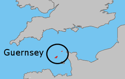
British Crown dependency in the
English Channel off the coast of
Normandy. As a
bailiwick, Guernsey embraces not only all
ten parishes on the Island of Guernsey, but also the islands of
Alderney and
Sark – each with their own parliament – and the smaller islands of
Herm,
Jethou and
Lihou. Although its defence is the responsibility of the
United Kingdom,
[2] the Bailiwick is not, despite common belief,
[citation needed] part of the United Kingdom, but, as its description suggests, a possession of the
British Crown (British monarchy). Consequently, though it lies within the
Common Travel Area of the
European Union, it is not part of the European Union.
Geography

The Bailiwick of Guernsey.
At
49°28′N 2°35′W, Alderney, Guernsey, Herm, Sark, and some other smaller islands have a total area of 78 square kilometres (30 sq mi) and a coastline of about 50 kilometres (31 mi). By itself, the island of Guernsey has a total area of 63.4 square kilometres (24.5 sq mi). Guernsey is situated 50 kilometres (31 mi) west of France's
Normandy coast and 120 kilometres (75 mi) south of
Weymouth, England and lies in the Gulf of
St Malo.
Lihou, a
tidal island, is attached to Guernsey by a
causeway at low tide. The terrain is mostly level with low hills in southwest.
[21][22] The southeastern point is
Jerbourg Point, used by the Germans during World War II. Elevation varies across the bailiwick from sea level to 114 m (374 ft) at
Le Moulin on Sark. The highest point in mainland Guernsey is Hautnez (111 m/364 ft), in Alderney at Le Rond But (101 m/331 ft), in Jethou (76 m/249 ft) and Herm (98 m/322 ft). Natural resources include cropland.
[23]
Guernsey contains two main geographical regions, the
Haut Pas, a high southern
plateau, and the
Bas Pas, a low-lying and sandy northern region. In general terms, the
Haut Pas is the more rural of the two, while the
Bas Pas is more residential and industrialised.


.jpg)