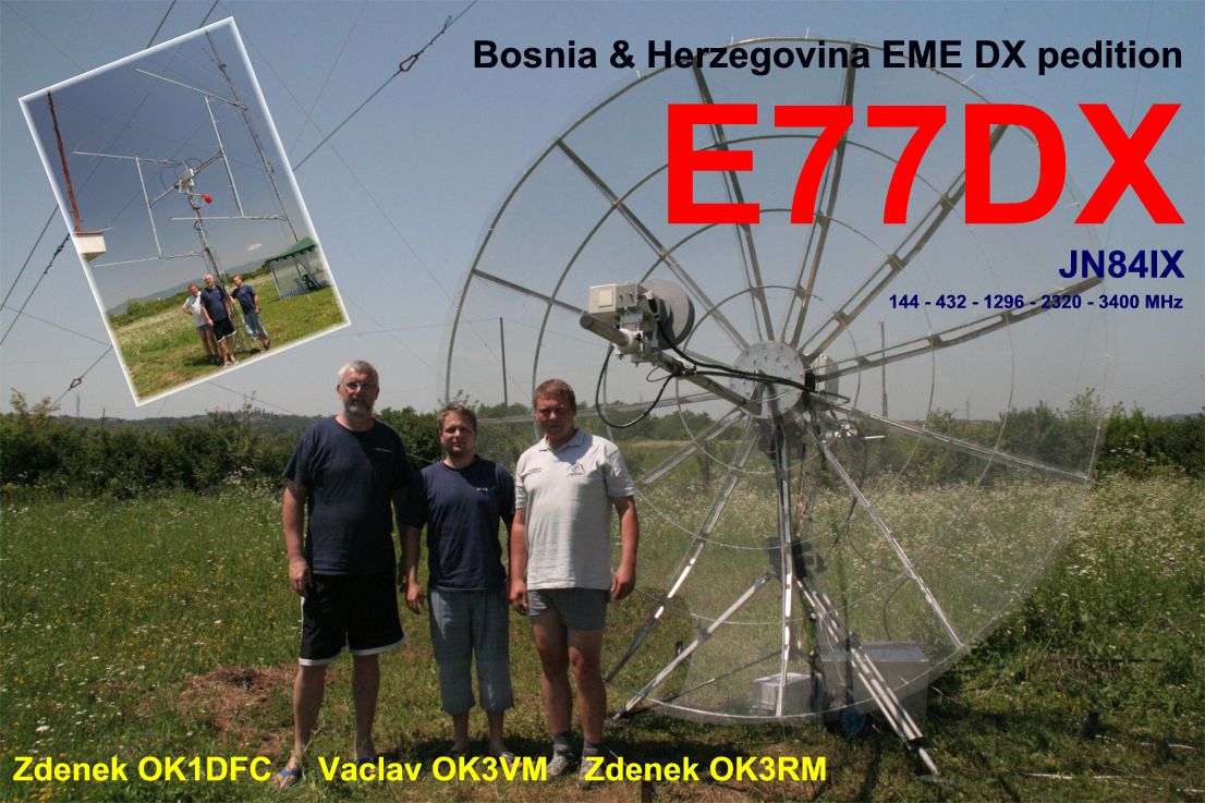
E77DX(Bosnia and Herzegovina) on 30m CW!!!
 E77DX E77DX Kralja Petra I Oslobodioca 58 Prijedor 79000 Bosnia and Herzegovina [+] Mailing label | ||
Lookups: 111800
| ||
| Email: Use mouse to view.. QSL: OE1EMS | ||
Hello,
and thanks for call me.
My main interest in HAM Radio is Contesting and DX-ing !
Large Antenna fields of E77DXare also home of E7DX contest team usualy very active in most major contests!
73s Braco
Ant. Setup:
160m 4 SQ Array, Vertical
80m 2 el Yagi @ 50m,4 SQ Array, Vertical, Inv v
40m 2 el Yagi @ 35m, 4SQ, Vertical
30m Vertical
20m 5/5/5 el yagi @ 39/26/13m, 4 el yagi @ 32m
17m 3 el yagi @ 17m
15m 6/6/6 el yagi @ 29/19/9m, 5 el yagi @ 20m
12m 4 el yagi @ 17m
10m 6/6 el yagi @ 24m/15, 5/5 el yagi @ 21/12m, 5 el yagi @ 18m
6m 6/6/6 el yagi @ 18/12/6m, 6/6 el yagi @ 15/9m, 6 el yagi @ 12m, 4 el yagi @ 10m
RX Ant Beverage : 250m-190 deg, 300m-260 deg, 450m-305 deg, 450m - 325 deg, 350m-350 deg, 420m- 15degf, 420m-40deg, 400m-65deg,330m-90deg
Shack have 4 operating positions with:
FT-1000MP, FT-1000MP MARK v Field, FT-2000D, 2 x FT-2000, K3
3 x homebrew "autotune" amp 1,8-30MHz, 2 x homebrew "autotune" amp 14-50Mhz, 1 x OM Power OM-3500A
Using Microham Microkeyer II, MK2R+, Station Masterfor interfacing PC-Radio and semi homebrew switching martix and filtering.
Due to increased number of QSL cards with insufficient return postage I'd like to advise fellows DX-ers that US$ 1 is not enough to send an air mail letter to any destination outside Europe. To send your QSL request direct please follow these instructions: Ensure that the QSO information on your card are complete and correct.
Enclose a self-addressed envelope (SAE). US Stations please include name of your country on the envelope. No address labels please!
Enclose return postage as follows:
non EU stations: 1 new style IRC, 3 US$ or 2 Euro . EU stations: 1 new style IRC, 2US$ or 1 Euro.
and thanks for call me.
My main interest in HAM Radio is Contesting and DX-ing !
Large Antenna fields of E77DXare also home of E7DX contest team usualy very active in most major contests!
73s Braco
Ant. Setup:
160m 4 SQ Array, Vertical
80m 2 el Yagi @ 50m,4 SQ Array, Vertical, Inv v
40m 2 el Yagi @ 35m, 4SQ, Vertical
30m Vertical
20m 5/5/5 el yagi @ 39/26/13m, 4 el yagi @ 32m
17m 3 el yagi @ 17m
15m 6/6/6 el yagi @ 29/19/9m, 5 el yagi @ 20m
12m 4 el yagi @ 17m
10m 6/6 el yagi @ 24m/15, 5/5 el yagi @ 21/12m, 5 el yagi @ 18m
6m 6/6/6 el yagi @ 18/12/6m, 6/6 el yagi @ 15/9m, 6 el yagi @ 12m, 4 el yagi @ 10m
RX Ant Beverage : 250m-190 deg, 300m-260 deg, 450m-305 deg, 450m - 325 deg, 350m-350 deg, 420m- 15degf, 420m-40deg, 400m-65deg,330m-90deg
Shack have 4 operating positions with:
FT-1000MP, FT-1000MP MARK v Field, FT-2000D, 2 x FT-2000, K3
3 x homebrew "autotune" amp 1,8-30MHz, 2 x homebrew "autotune" amp 14-50Mhz, 1 x OM Power OM-3500A
Using Microham Microkeyer II, MK2R+, Station Masterfor interfacing PC-Radio and semi homebrew switching martix and filtering.
Want QSL card from E77DX? Pleaseread QSL policybelow!!!
Due to increased number of QSL cards with insufficient return postage I'd like to advise fellows DX-ers that US$ 1 is not enough to send an air mail letter to any destination outside Europe. To send your QSL request direct please follow these instructions: Ensure that the QSO information on your card are complete and correct.
Enclose a self-addressed envelope (SAE). US Stations please include name of your country on the envelope. No address labels please!
Enclose return postage as follows:
non EU stations: 1 new style IRC, 3 US$ or 2 Euro . EU stations: 1 new style IRC, 2US$ or 1 Euro.
20121201 1110UTC 106.99kHz E77DX
Date : 01/Dec/2012 1110UTC
Freq : 106.98kHz CW
Rig : ICOM IC-7200
ANT : LOOP(for 20m..not enough gain)
PC recording
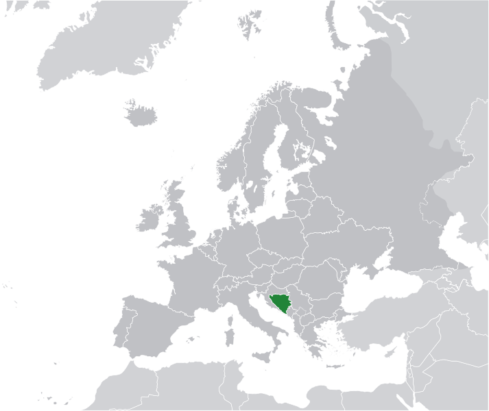
Bosnia and Herzegovina ( i/ˈbɒzniə ən hɛrtsəɡoʊˈviːnə/; Bosnian and Serbian: Bosna i Hercegovina/Босна и Херцеговина;Croatian: Bosna i Hercegovina), sometimes called Bosnia-Herzegovina, is a country in Southeastern Europe, on the Balkan Peninsula. Its capital and largest city is Sarajevo. Bordered by Croatia to the north, west and south, Serbia to the east, andMontenegro to the southeast, Bosnia and Herzegovina is almost landlocked, except for the 20 kilometres (12 miles) of coastline on the Adriatic Sea surrounding the city of Neum.[7][8] In the central and southern interior of the country the geography is mountainous, in the northwest it is moderately hilly, and the northeast is predominantly flatland. The inland is a geographically larger region and has a moderate continental climate, bookended by hot summers and cold and snowy winters. The southern tip of the country has aMediterranean climate and plain topography.
Bosnia and Herzegovina is a region that traces permanent human settlement back to the Neolithic age, during and after which it was populated by several Illyrian and Celtic civilizations. Culturally, politically, and socially, the country has one of the richest histories in the region, having been first settled by the Slavic peoples that populate the area today from the 6th through to the 9th centuries AD. They then established the first independent banate in the region, known as the Banate of Bosnia, in the early 12th century upon the arrival and convergence of peoples that would eventually come to call themselves Dobri Bošnjani ("Good Bosnians"). This evolved into the Kingdom of Bosnia in the 14th century, after which it was annexed into the Ottoman Empire, under whose rule it would remain from the mid 15th to the late 19th centuries. The Ottomans brought Islam to the region, and altered much of the cultural and social outlook of the country. This was followed by annexation into the Austro-Hungarian Monarchy, which lasted up until World War I. Following the dissolution of the Socialist Federal Republic of Yugoslavia, the countryproclaimed independence in 1992, which was followed by the Bosnian War, lasting until late 1995.
 Today, the country maintains high literacy, life expectancy and education levels and is one of the most frequently-visited countries in the region.[9] Bosnia and Herzegovina is regionally and internationally renowned for its natural beauty and cultural heritageinherited from six historical civilizations, its cuisine, winter sports, its eclectic and unique music, architecture and the Sarajevo Film Festival and Sarajevo Jazz Festival, both the largest and most prominent of their kind in Southeastern Europe.[10][11]
The country is home to three ethnic groups or, officially, constituent peoples, a term unique for Bosnia and Herzegovina. Bosniaksare the largest group of the three, with Serbs second and Croats third. Regardless of ethnicity, a citizen of Bosnia and Herzegovina is often identified in English as a Bosnian. The terms Herzegovinian and Bosnian are maintained as a regional rather than ethnic distinction, and the region of Herzegovina has no precisely defined borders of its own. Moreover, the country was simply called "Bosnia" until the Austro-Hungarian occupation at the end of the nineteenth century.[12]
Bosnia and Herzegovina has a bicameral legislature and a three-member Presidency composed of a member of each major ethnic group. However, the central government's power is highly limited, as the country is largely decentralized and comprises two autonomous entities: the Federation of Bosnia and Herzegovina and Republika Srpska, with a third region, the Brčko District, governed under local government. The Federation of Bosnia and Herzegovina is itself complex and consists of 10 federal units -cantons. The country is a potential candidate for membership to the European Union and has been a candidate for NATOmembership since April 2010, when it received a Membership Action Plan at the summit in Tallinn. Additionally, the country has been a member of the Council of Europe since April 2002 and a founding member of the Mediterranean Union upon its establishment in July 2008.
 Manager