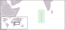
Monday, November 12, 2012

V84SMD(Brunei) on 20m SSB!!!

V84SMD(Brunei)  on 20m SSB!!!


Brunei Listeni/brˈn/, officially the Nation of Brunei, the Abode of Peace[8](MalayNegara Brunei DarussalamJawiنڬارا بروني دارالسلامArabicدولة بروناي، دار السلام‎), is a sovereign state located on the north coast of the island ofBorneo, in Southeast Asia. Apart from its coastline with the South China Sea, it is completely surrounded by the state of SarawakMalaysia, and it is separated into two parts by the Sarawak district of Limbang. It is the only sovereign state completely on the island of Borneo, with the remainder of the island belonging toMalaysia and IndonesiaBrunei's population was 401,890 in July 2011.[9]
The official national history claims that Brunei can trace its beginnings to the 7th century, when it was a subject state of the Srivijayan empire under the name P'o-li. It later became a vassal state of Majapahit empire before converting to Islam in the 15th century. At the peak of its empire, the sultanate had control that extended over the coastal regions of modern-day Sarawak and Sabah, the Sulu archipelago, and the islands off the northwest tip of Borneo. The thalassocracywas visited by the remnants of the Ferdinand Magellan Expedition in 1521 after Magellan was killed some weeks earlier on 27 April of that year and fought theCastille War in 1578 against Spain. Its empire began to decline with the forced ceding of Sarawak to James Brooke and the ceding of Sabah to the British North Borneo Chartered Company. After the loss of Limbang, Brunei finally became a British protectorate in 1888, receiving a resident in 1906. In the years after the Japanese wartime occupation during World War II, it formalised a constitutionand fought an armed rebellion.[10] Brunei regained its independence from theUnited Kingdom on 1 January 1984. Economic growth during the 1970s and 1990s, averaging 56% from 1999 to 2008, has transformed Brunei Darussalam into a newly industrialised country.
Brunei has the second highest Human Development Index among the South East Asia nations after Singapore, and is classified as a developed country.[11]According to the International Monetary Fund (IMF), Brunei is ranked 5th in the world by gross domestic product per capita at purchasing power parity. The IMF also states in a 2011 estimate that Brunei was one of two countries (the other being Libya) with their public debt at 0% of the national GDP. Forbes also ranks Brunei as the fifth richest nation out of 182 nations due to its extensive petroleum and natural gas fields.[12]

V84SMD Brunei flag Brunei MDXC Dxpedition 2012 team : IZ8CCW-I2VGW-V85TX-IZ2KXC-IZ2GNQ-I2DMI-
YB3MM-ON7RN-F5EOT-IK2LTR-V85AVE-V85AX-F1HRE-F6BIV-I8YGZ-DJ7JC
DJ9RR-IT9ZZO-F2JD-IW2ERT-HB9OCR-DL3GA-YO9XC-YO9ADN-IZ5GST
Brunei


LoTW files will be uploaded by the end of March 2013 (four months after QRT).
Manager’s Requirements:
for paypal: 2 euro for Europe and 3 euro out side Europe thanks.
For direct qsl, I require that you provide appropriate SASE or SAE+ current IRC or SAE+greenstamp fordirect mail return.
To send a standard 20g letter from Italy are necessary:
€ 0.75 to ship a letter to Europe
€ 1.60 to ship a letter to USA
€ 2.00 to ship a letter to Oceania & South America
for OQRS via paypal please send 2 euro for europe, 3 euro for others.
ALL QSLs received without these requirements for direct return will processed via the bureau.
PLEASE!If you send your QSL via one route, do not send a duplicate QSL via another route. For example, if you send a card direct, please DO NOT also send a ca


Many Thanks QSO 73's!! from JA's

20121112 0720UTC 14200kHz V84SMD
Date : 12/Nov/2012 0720UTC 
Freq : 14200kHz USB 
Rig : ICOM IC-7200 
ANT : LOOP 
PC recording


8J1RL(Antarctica) on 30m CW & 40m CW!!!

8J1RL(Antarctica) on 30m CW & 40m CW!!!

Showa Station (昭和基地 Shōwa Kichi), also sometimes spelledSyowa,[1] is a Japanese research station located on East Ongul Island inAntarctica. Built in 1957, the station is named for the era in the Japanese calendar during which it was established, the Showa period.
Showa Station serves as a research outpost for astronomymeteorology,biology and earth sciences. It comprises over 60 separate buildings, large and small, including a 3-story administration building, living quarters, power plant, sewage treatment facility, environmental science building, observatory, data processing facility, satellite building, ionospheric station, incinerator, earth science building, and radiosonde station. Also present are fuel tanks, water storage, solar panels, a heliport, a water retention dam, and an enormous radio transmitter.


昭和基地しょうわきち)は、南極圏内の東オングル島にある日本の観測基地。南緯69度00分22秒 東経39度35分24秒 座標南緯69度00分22秒 東経39度35分24秒、標高29.18m。基地の名称は建設された時代の元号昭和」にちなむ。

昭和基地は天体気象地球科学生物学の観測を行う施設である。施設は大小60以上の棟から成り、3階建ての管理棟のほか、居住棟、発電棟、汚水処理棟、環境科学棟、観測棟、情報処理棟、衛星受信棟、焼却炉棟、電離層棟、地学棟、ラジオゾンデを打ち上げる放球棟があり、このほか、大型受信アンテナ、燃料タンク、ヘリポート、太陽電池パネル、貯水用の荒金ダムもある。また、建設中の自然エネルギーを研究する為の棟が53次観測隊で完成予定である。1000キロ離れた南極大陸内にドームふじ基地がある。余暇(通常業務が休みになる南極時間の土日、および臨時で日本時間のこどもの日)を利用して基地職員によるアマチュア無線局(8J1RL)の運用が行われている。多くの建物は木造プレハブ構造で、大手住宅メーカーのミサワホームが製造したものが使用されている。
医務室、管理棟、厨房、食堂、通信室、公衆電話室、図書室、娯楽室などは管理棟内にある。医務室には手術が行える設備があるが、実際は非常時用で手術例はほとんどない。
郵政民営化までは郵便局もあり、現在は郵便事業株式会社銀座支店昭和基地内分室が置かれ、日本国内と同料金で手紙やハガキを日本本土へ送る事ができる。かつては昭和基地内郵便局の郵便番号として100-70(国立極地研究所扱い。枝番70は一旦閉鎖された基地の業務が再開された1970年にちなむ)が宛てられていたが、現在は特に定められていない。
荒天時は使用しない特殊な棟(放球棟など)を除き、各棟は渡り廊下で接続されている。これは、他国の南極基地で3 m離れた別棟のトイレに向かった隊員が悪天候で遭難死する事故があり、このような事故を防ぐためである。
南極地域観測隊員は約60名で、そのうち約40名が越冬する。翌年度の隊が来た観測船で前年の越冬隊が帰国するため、基地には常に人がいることになる。所管は文部科学省と極地研究所。2009年2月から2010年2月を担当したのが50次観測隊で、2010年2月からは51次観測隊、2011年2月からは52次観測隊の担当となる。越冬交代式は近年通常2月1日に行われている。1次越冬隊の際に有名になった樺太犬など犬ぞり用の犬は、その後環境保護に関する南極条約議定書(付属書II第四条)により生きた動物や植物等の南極への持ち込みが禁止されたため、現在はいない。
タイムゾーンは基地の経度からUTC+3時間(JST-6時間)としている。隊員は国家公務員の男性であるが、専門技能を持った民間企業の社員や、みなし隊員として民間企業出向の女性も派遣されている。
今回は14MHz用アンテナのため受信のみ。
30mBand(10MHz)ってのはこんなに良く聞えるものと感心した次第。
これは先日14MHzRTTYでQSOしたもの
夏場に聞いて以来、機会があればと思っていた矢先、RTTYでのQRVに遭遇した。
案外そっけないものだった
どこかのOMが言っていたが、一度つながった
DXは案外簡単に次も出来るようになると・・・。


20121111 1813UTC 10106.8kHz 8J1RL

Date : 11/Nov/2012 1813UTC 
Freq : 10106.8kHz CW 
Rig : ICOM IC-7200 
ANT : LOOP 
PC recording


20121111 1811UTC 7005.8kHz 8J1RL 

Date : 11/Nov/2012 1813UTC 
Freq : 7005.8kHz CW 
Rig : ICOM IC-7200 
ANT : LOOP(for 20m not enough gain) 
PC recording

Monday, November 5, 2012

8Q7EJ(Maldives) on 20m CW!!!

8Q7EJ(Maldives) on 20m CW!!!


8Q7EJ Maldives flag Maldives Jim Evans

Macclesfield SK11 9SW
England

[+] Mailing label


Many thanks Jim san, and Many JA's say "Hello"


Maldives (Listeni/ˈmɔːldvz/, /ˈmɔːldvz/ or /ˈmældvz/[7]; Dhivehi: ދިވެހިރާއްޖެ Dhivehi Raa'je), officially the Republic of Maldives (Dhivehi: ދިވެހިރާއްޖޭގެ ޖުމްހޫރިއްޔާ Dhivehi Raa'jeyge Jumhooriyya) and also referred to as the Maldive Islands, is an island nation in theIndian Ocean consisting of a double chain of twenty-six atolls, orientated north-south, that lie between Minicoy Island (the southernmost part of Lakshadweep, India) and the Chagos Archipelago. The chains stand in the Laccadive Sea, about 700 kilometres (430 mi) south-west of Sri Lanka and 400 kilometres (250 mi) south-west of India.
From the mid-sixteenth century, the Maldives was dominated by colonial powers: Portugal,the Netherlands and Britain. The Dutch referred to the islands as the "Maldivische Eilanden" (pronounced [mɑlˈdivisə ˈɛi̯lɑndə(n)]),[citation needed] while the British anglicised the local name for the islands first as the "Maldive Islands" and later as the "Maldives". The islands gained independence from the British in 1965 and became a republic ruled by asultanate and an authoritarian government.
The Maldives archipelago is located on top of the Chagos-Maldives-Laccadive Ridge, a vast submarine mountain range in the Indian Ocean. Maldives also form a terrestrial ecoregion together with the Chagos and the Lakshadweep.[8] The Maldives atolls encompass a territory spread over roughly 90,000 square kilometres (35,000 sq mi), making the country one of the world's most geographically dispersed. Its population of 328,536 (2012) inhabits 200 of its 1,192 islands.[9] In 2006, Maldives' capital and largest city Malé, located at the southern edge of North Malé Atoll, had a population of 103,693.[10][11] Malé is one of the Maldives' administrative divisions and, traditionally, it was the "King's Island" where the ancient Maldive royal dynasties were enthroned.
Maldives is the smallest Asian country in both population and land area. With an average ground level of 1.5 metres (4 ft 11 in) above sea level, it is the planet's lowest country.[12] It is also the country with the lowest natural highest point in the world, at 2.4 metres (7 ft 10 in).[12] Not surprisingly, forecasts of Maldives' inundation are a great concern for the Maldivian people.

20121105_1148UTC_14024kHz_8Q7EJ


Date : 05/Nov/2012 1148UTC 
Freq : 14023.9kHz CW 
Rig : ICOM IC-7200 
ANT : LOOP 
PC recording


PY6RT(Brazil) on 20m USB!!

PY6RT(Brazil) on 20m USB!!


Brazil Listeni/brəˈzɪl/ (PortugueseBrasilIPA: [bɾaˈziw][8]), officially the Federative Republic of Brazil[9][10] (PortugueseRepública Federativa do BrasilAbout this sound listen), is the largest country in South America and in the Latin America region. It is the world's fifth largest country, both by geographical area and by population with over 193 million people.[11][4] It is the largestLusophone country in the world, and the only one in the Americas.[11]
Bounded by the Atlantic Ocean on the east, Brazil has a coastline of 7,491 km (4,655 mi).[11] It is bordered on the north by VenezuelaGuyanaSuriname and the French overseas region ofFrench Guiana; on the northwest by Colombia; on the west by Bolivia and Peru; on the southwest by Argentina and Paraguay and on the south by Uruguay. Numerous archipelagosform part of Brazilian territory, such as Fernando de NoronhaRocas AtollSaint Peter and Paul Rocks, and Trindade and Martim Vaz.[11] It borders all other South American countries exceptEcuador and Chile.
Brazil was a colony of Portugal from the landing of Pedro Álvares Cabral in 1500 until 1815, when it was elevated to the rank of kingdom and the United Kingdom of Portugal, Brazil and the Algarves was formed. The colonial bond was in fact broken in 1808, when the capital of thePortuguese colonial empire was transferred from Lisbon to Rio de Janeiro, after Napoleon invaded Portugal.[12] Independence was achieved in 1822 with the formation of the Empire of Brazil, a unitary state governed under a constitutional monarchy and a parliamentary system. The country became a presidential republic in 1889, when a military coup d'état proclaimed the Republic, although the bicameral legislature, now called Congress, dates back to the ratification of the first constitution in 1824.[12] Its current Constitution, formulated in 1988, defines Brazil as a Federal Republic.[13] The Federation is formed by the union of the Federal District, the 26 States, and the 5,564 Municipalities.[13][14]
The Brazilian economy is the world's sixth largest by nominal GDP and the seventh largest bypurchasing power parity (as of 2011).[15][16] Brazil is one of the world's fastest growing major economies. Economic reforms have given the country new international recognition.[17] Brazil is a founding member of the United Nations, the G20CPLPLatin Union, the Organization of Ibero-American States, the Organization of American StatesMercosul and the Union of South American Nations, and is one of the BRIC countries. Brazil is also one of the 17 Megadiverse countries, home to diverse wildlifenatural environments, and extensive natural resources in a variety of protected habitats.[11] With a confirmed presence of 67 isolated tribes by theFundação Nacional do Índio, Brazil has the world's greatest number of uncontacted peoples.[18]


PY6RT Brazil flag Brazil Roberto Tourinho - BETO

Feira De Santana, BA 44088450
Brazil

[+] Mailing label


20121105 0847UTC 14200kHz PY6RT

Date : 05/Nov/2012 0847UTC
Freq : 14200kHz USB
Rig : ICOM IC-7200
ANT : LOOP
PC recording